1930s Maps of Santa Clarita, California
Explore 8 historic maps of Santa Clarita from the 1930s. These maps offer a rare glimpse into what life looked like during the 1930s — showing old roads, neighborhoods, homes, and landmarks that have changed or disappeared over time.
Whether you're researching your family's past, planning a metal detecting trip, or studying how Santa Clarita's landscape evolved across the 1930s, these high-resolution maps are a powerful tool for exploring the history of this region.
- Focus on a specific era: All maps on this page are from the 1930s, giving you a focused view of this time period.
- See what’s changed: Compare century-old streets, trails, and buildings to today's modern landscape using overlays and satellite layers.
- Research with precision: Use these maps for genealogy, historical research, land use analysis, or educational projects.
- View, download, or print: Maps are fully viewable online in high resolution, and can be downloaded or printed for your own records.
Start exploring Santa Clarita's history through authentic maps from the 1930s. This is your window into the past.
Santa Clarita, CA maps
(8)- 1931 Map of Castaic
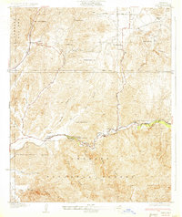
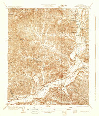 1931 Castaic1931 Print · USGSCastaic and the Santa Clara River valley appear here in the early 1930s, caught between the era of ranching and the rise of the oil industry. Researchers can find family landmarks like Sloane Ranch and the Val Verde Lodge, or trace the old U S Highway No 99.
 - 1932 Map of Humphreys
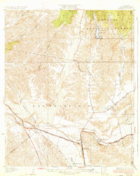
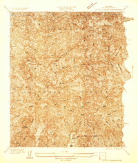
 1932 Humphreys1932 Print · USGSCanyon country north of Los Angeles comes into focus in the early 1930s as the Sierra Highway and Southern Pacific drive development. Researchers can trace the layout of rural crossroads like Solamint and locate early landmarks such as New Era Sch and Honby Sch.3 unique versions available
 - 1933 Map of Saugus
 1933 Saugus1933 Print · USGSThe Santa Clarita Valley area appears here during the early automotive era, showing the intersection of vital rail lines and mountain highways. Genealogists and historians can trace Saugus and Baker Ranch alongside early aviation landmarks like the Dept. of Commerce Landing Field.4 unique versions available
 - 1933 Map of Newhall
 1933 Newhall1933 Print · USGSNewhall and the northern Santa Susana Mountains are shown in the early thirties as vital transit corridors for rail and road. Researchers can trace the path of the Southern Pacific through the Tunnel or locate the Dept of Commerce Landing Field.4 unique versions available
 - 1933 Map of Lang
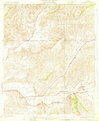
 1933 Lang1933 Print · USGSUpper Los Angeles County in the early thirties centers on the vital rail and road corridors through the Santa Clarita Valley. Genealogists and historians can trace the footprint of early mountain life at Sunny Slope Ranch, the rail stop at Lang, and the Champion Mine.3 unique versions available
 - 1934 Map of Little Tujunga
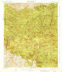
 1934 Little Tujunga1934 Print · USGSThe San Gabriel canyons come alive in the 1930s, showing a rugged landscape of high-altitude sanatoriums and family ranches. Trace the locations of De Mille Ranch, the Acme Mine, and the sprawling grounds of the Fairview Sanatorium.
 - 1935 Map of Sylmar
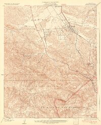
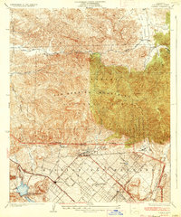 1935 Sylmar1935 Print · USGSThe San Fernando Valley meets the mountains in the 1930s as the suburbs began to climb into the foothills. Genealogists and historians can trace the early streets of Sylmar, the grounds of the El Retiro School for Girls, and the sprawling Ex Mission San Fernando lands.3 unique versions available
 - 1939 Map of Little Tujunga
 1939 Little Tujunga1939 Print · USGSLos Angeles County's front range was a landscape of remote ranches and fire lookouts in the late 1930s. Researchers can locate canyon homesteads such as De Mille Ranch and Watts Ranch, or trace early health retreats like Fairview Sanatorium.3 unique versions available
End of results
Showing maps 1-8 of 8
Top cities near Santa Clarita
- Los Angeles historical maps
- Glendale historical maps
- Palmdale historical maps
- Lancaster historical maps
- Simi Valley historical maps
- Burbank historical maps
See more
Top neighborhoods of Santa Clarita
- Pardee historical maps
- Humphreys historical maps
- Bouquet Junction historical maps
- Rancho Santa Clarita historical maps
- Waltz historical maps
- Elayon historical maps
See more
Frequently asked questions
- What are the different types of historical maps available for Santa Clarita?
- What is the oldest map of Santa Clarita?
- Where can I purchase historical maps of Santa Clarita for my home or office?
- Where can I download high-res historical maps of Santa Clarita?
- Are there historical topographic maps available for Santa Clarita?
- Is there historical aerial imagery available for Santa Clarita?
- Where are historical maps of Santa Clarita sourced from?