1950s Maps of Santa Clarita, California
Explore 5 historic maps of Santa Clarita from the 1950s. These maps offer a rare glimpse into what life looked like during the 1950s — showing old roads, neighborhoods, homes, and landmarks that have changed or disappeared over time.
Whether you're researching your family's past, planning a metal detecting trip, or studying how Santa Clarita's landscape evolved across the 1950s, these high-resolution maps are a powerful tool for exploring the history of this region.
- Focus on a specific era: All maps on this page are from the 1950s, giving you a focused view of this time period.
- See what’s changed: Compare century-old streets, trails, and buildings to today's modern landscape using overlays and satellite layers.
- Research with precision: Use these maps for genealogy, historical research, land use analysis, or educational projects.
- View, download, or print: Maps are fully viewable online in high resolution, and can be downloaded or printed for your own records.
Start exploring Santa Clarita's history through authentic maps from the 1950s. This is your window into the past.
Santa Clarita, CA maps
(5)- 1952 Map of Oat Mountain, 1953 Print
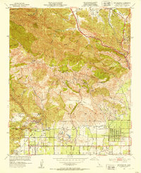 1952 Oat Mountain1953 Print · USGSThe northwest San Fernando Valley met the rugged Santa Susana range in the early fifties, just as citrus groves gave way to suburban tracts. Researchers can trace the legendary Iverson Ranch film location, the historic Southern Pacific rail tunnel, and the Oakwood Cem grounds.8 unique versions available
 - 1952 Map of Newhall, 1953 Print
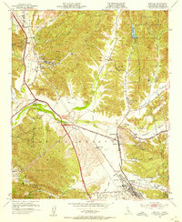 1952 Newhall1953 Print · USGSThe Santa Clarita Valley was a landscape of citrus, cattle, and crude oil in the early fifties before it became a suburban corridor. Genealogists and historians can trace old family holdings like Bonelli Ranch, find early schools such as Hart School, and locate the Oil Wells that fueled the local economy.6 unique versions available
 - 1953 Map of San Fernando, 1954 Print
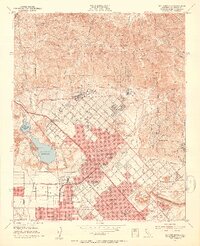 1953 San Fernando1954 Print · USGSThe San Fernando Valley meets the mountains in the early fifties during a period of rapid suburban and industrial expansion. Genealogists and local historians can trace the San Fernando Mission, find the Whiteman Air Park, and locate long-standing medical institutions like the Olive View Sanatorium.3 unique versions available
 - 1955 Map of Los Angeles
 1955 Los Angeles1955 Print · USGSThe mid-century transformation of Southern California comes into focus as the urban sprawl of Los Angeles meets the wilderness of the Santa Monica Mountains. Researchers can trace the development of post-war suburbs alongside historic landmarks like the Santa Barbara Lighthouse and early industrial sites such as the Good Luck Mine.
 - 1959 Map of Los Angeles
 1959 Los Angeles1959 Print · USGSCoastal California and the high desert met in a period of booming growth after the war. Researchers can trace early aviation and military history at the Point Mugu Air Missile Test Ctr or locate desert mining sites like the Double Eagle Mine.3 unique versions available
End of results
Showing maps 1-5 of 5
Top cities near Santa Clarita
- Los Angeles historical maps
- Glendale historical maps
- Palmdale historical maps
- Lancaster historical maps
- Simi Valley historical maps
- Burbank historical maps
See more
Top neighborhoods of Santa Clarita
- Pardee historical maps
- Humphreys historical maps
- Bouquet Junction historical maps
- Rancho Santa Clarita historical maps
- Waltz historical maps
- Elayon historical maps
See more
Frequently asked questions
- What are the different types of historical maps available for Santa Clarita?
- What is the oldest map of Santa Clarita?
- Where can I purchase historical maps of Santa Clarita for my home or office?
- Where can I download high-res historical maps of Santa Clarita?
- Are there historical topographic maps available for Santa Clarita?
- Is there historical aerial imagery available for Santa Clarita?
- Where are historical maps of Santa Clarita sourced from?