1990s Maps of Santa Clarita, California
Explore 3 historic maps of Santa Clarita from the 1990s. These maps offer a rare glimpse into what life looked like during the 1990s — showing old roads, neighborhoods, homes, and landmarks that have changed or disappeared over time.
Whether you're researching your family's past, planning a metal detecting trip, or studying how Santa Clarita's landscape evolved across the 1990s, these high-resolution maps are a powerful tool for exploring the history of this region.
- Focus on a specific era: All maps on this page are from the 1990s, giving you a focused view of this time period.
- See what’s changed: Compare century-old streets, trails, and buildings to today's modern landscape using overlays and satellite layers.
- Research with precision: Use these maps for genealogy, historical research, land use analysis, or educational projects.
- View, download, or print: Maps are fully viewable online in high resolution, and can be downloaded or printed for your own records.
Start exploring Santa Clarita's history through authentic maps from the 1990s. This is your window into the past.
Santa Clarita, CA maps
(3)- 1995 Map of Mint Canyon, 1999 Print
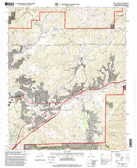 1995 Mint Canyon1999 Print · USGSThe Santa Clarita Valley was undergoing significant suburban growth in the mid-nineties, even as it remained framed by the deep canyons of the Angeles National Forest. Local researchers can trace family landmarks and community sites like Solemint, the Sulphur Spring Sch., and the historic Southern Pacific rail line.
 - 1995 Map of San Fernando, 1999 Print
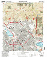 1995 San Fernando1999 Print · USGSThe San Fernando Valley at the end of the century shows a dense suburban landscape pushing against the foothills of the Angeles National Forest. Researchers can trace local heritage through landmarks like Pioneer Memorial Cem, the San Fernando Valley Juvenile Hall, and Whiteman Air Park.
 - 1995 Map of Newhall, 1999 Print
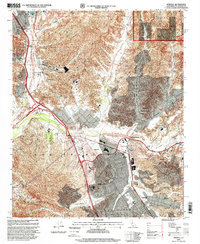 1995 Newhall1999 Print · USGSSanta Clarita and the Santa Clara River valley are shown in a period of significant growth during the mid-nineties. Local historians can trace the evolution of Saugus and Newhall or locate landmarks like the Newhall Oil Field and Saugus School.
End of results
Showing maps 1-3 of 3
Top cities near Santa Clarita
- Los Angeles historical maps
- Glendale historical maps
- Palmdale historical maps
- Lancaster historical maps
- Simi Valley historical maps
- Burbank historical maps
See more
Top neighborhoods of Santa Clarita
- Pardee historical maps
- Humphreys historical maps
- Bouquet Junction historical maps
- Rancho Santa Clarita historical maps
- Waltz historical maps
- Elayon historical maps
See more
Frequently asked questions
- What are the different types of historical maps available for Santa Clarita?
- What is the oldest map of Santa Clarita?
- Where can I purchase historical maps of Santa Clarita for my home or office?
- Where can I download high-res historical maps of Santa Clarita?
- Are there historical topographic maps available for Santa Clarita?
- Is there historical aerial imagery available for Santa Clarita?
- Where are historical maps of Santa Clarita sourced from?