1900s (20th Century) Maps of Two Harbors, California
Explore 10 historic maps of Two Harbors from the 1900s (20th Century). These maps offer a rare glimpse into what life looked like during the 1900s — showing old roads, neighborhoods, homes, and landmarks that have changed or disappeared over time.
Whether you're researching your family's past, planning a metal detecting trip, or studying how Two Harbors's landscape evolved across the 1900s, these high-resolution maps are a powerful tool for exploring the history of this region.
- Focus on a specific era: All maps on this page are from the 1900s, giving you a focused view of this time period.
- See what’s changed: Compare century-old streets, trails, and buildings to today's modern landscape using overlays and satellite layers.
- Research with precision: Use these maps for genealogy, historical research, land use analysis, or educational projects.
- View, download, or print: Maps are fully viewable online in high resolution, and can be downloaded or printed for your own records.
Start exploring Two Harbors's history through authentic maps from the 1900s. This is your window into the past.
Two Harbors, CA maps
(10)- 1943 Map of Santa Catalina North, 1956 Print
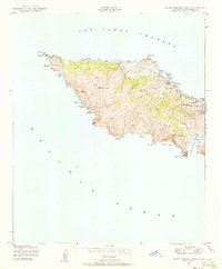
 1943 Santa Catalina North1956 Print · USGSSanta Catalina Island's northern reaches are detailed here during the mid-forties, showing a landscape of ranching and early development. Trace inland landmarks like Wrigley Ranch and Black Jack Camp, or follow the coast to Empire Landing and Isthmus Cove.4 unique versions available
 - 1943 Map of Santa Catalina West, 1956 Print
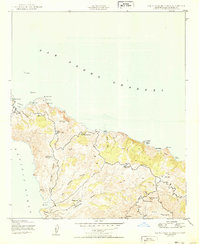
 1943 Santa Catalina West1956 Print · USGSSanta Catalina's western reaches appear here as they were during the mid-1940s, showing an island of steep ridges and isolated coves. Trace the maritime history of Catalina Harbor and find early camp locations like the Girl Scouts Camp or Parsons Landing.4 unique versions available
 - 1949 Map of Long Beach
 1949 Long Beach1949 Print · USGSSouthern California at the start of the post-war boom shows the rapid development of the Los Angeles basin and the South Bay. Genealogists and historians can trace the evolution of early suburbs like Gardena and Lynwood or the coastal defenses at Ft MacArthur Lower Reservation.2 unique versions available
 - 1950 Map of Santa Catalina West
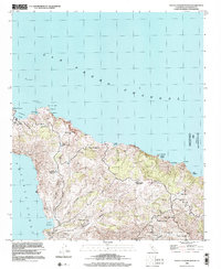
 1950 Santa Catalina West1950 Print · USGSWestern Santa Catalina Island in the mid-century remains a landscape of steep peaks and sheltered coves. Researchers can trace remote coastal sites like Parsons Landing, the Girl Scouts Camp, and the high summit of Mt Torquemada.
 - 1950 Map of Santa Catalina North
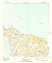
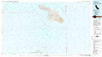
 1950 Santa Catalina North1950 Print · USGSNorthern Santa Catalina Island in the mid-forties reveals a landscape of cattle ranching and isolated coastal landings. Trace the footprint of the Wrigley Ranch, find the inland Black Jack Camp, and explore the diverse coves from Fishermans Cove to Goat Harbor.
 - 1957 Map of Long Beach
 1957 Long Beach1957 Print · USGSThe Los Angeles coast and the Channel Islands appear here during the mid-fifties era of rapid suburbanization and naval expansion. Genealogists and researchers can locate early industrial neighborhoods like South Gate and trace military boundaries at Ft MacArthur Upper Reservation or the remote San Nicolas Island.4 unique versions available
 - 1958 Map of Long Beach
 1958 Long Beach1958 Print · USGSCoastal Southern California is shown during a mid-century period of intense suburbanization and military readiness. Genealogists and historians can trace the growth of Long Beach, identify early neighborhoods in Lakewood Village, or locate the bounds of Ft MacArthur Lower Reservation.
 - 1960 Map of Long Beach
 1960 Long Beach1960 Print · USGSCoastal California at the height of post-war expansion reveals a dense network of suburban growth and maritime industry. Trace the development of the South Bay and inland neighborhoods like Lakewood Village, or explore the topography of Santa Catalina Island and Los Angeles Harbor.2 unique versions available
 - 1981 Map of Santa Catalina Island
 1981 Santa Catalina Island1981 Print · USGSSanta Catalina and San Clemente islands are shown in the early eighties, detailing the rugged interior peaks and isolated coastal coves of Los Angeles County. Trace the geographic layout of Avalon, the air connections at the Landing Field, and military installations at the Naval Ocean Systems Center.2 unique versions available
 - 1998 Map of Santa Catalina North, 2002 Print
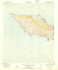
 1998 Santa Catalina North2002 Print · USGSSanta Catalina Island in the late nineties reveals a rugged landscape of ranching history and coastal navigation. Researchers can trace the interior ranching infrastructure at Wrigley Ranch and Black Jack Camp or locate coastal landmarks like Empire Landing.
End of results
Showing maps 1-10 of 10
Top cities near Two Harbors
Frequently asked questions
- What are the different types of historical maps available for Two Harbors?
- What is the oldest map of Two Harbors?
- Where can I purchase historical maps of Two Harbors for my home or office?
- Where can I download high-res historical maps of Two Harbors?
- Are there historical topographic maps available for Two Harbors?
- Is there historical aerial imagery available for Two Harbors?
- Where are historical maps of Two Harbors sourced from?