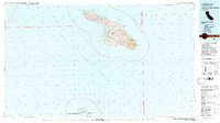
1981 Map of Santa Catalina Island
USGS Topo · Published 1981About this map
Santa Catalina Island dominates this 1980s offshore study, showing the topographic complexity of the Channel Islands before modern development intensified. The settlement of Avalon sits at its eastern harbor, while the narrow neck of the island is anchored by Two Harbors, separating Isthmus Cove from Catalina Harbor. High points like Mt Orizaba and Mt Banning illustrate the interior's steep drainage patterns, including Cottonwood Canyon and Big Springs Canyon. To the south, the map details the northern tip of San Clemente Island, specifically the Naval Ocean Systems Center San Clemente Island Facility and the Reservation Bdy. This edition is particularly valuable for its inclusion of Bureau of Land Management protraction data, marking official offshore blocks across the San Pedro Channel and the Outer Santa Barbara Passage.
Find a feature on this map
47 named features on this map. Tap any name to fly to it.
Don’t see what you’re looking for? This feature index may not catch every label — zoom into the map to look around manually.
Map Details
Editions of this 1981 Santa Catalina Island Map
2 editions found
Other maps of this area

1896 · Santa Ana
USGS Topo · 1:62,500

1896 · Las Bolsas
USGS Topo · 1:62,500

1896 · San Pedro
USGS Topo · 1:62,500

1901 · Southern California Sheet No. 1
USGS Topo · 1:250,000

1901 · Santa Ana
USGS Topo · 1:62,500

1902 · Capistrano
USGS Topo · 1:125,000

1902 · Corona
USGS Topo · 1:125,000

1904 · Southern California Sheet No. 1
USGS Topo · 1:250,000

1906 · Capistrano
USGS Topo · 1:125,000
1941 · Las Bolsas
USGS Topo · 1:62,500