1920s Maps of Madera, California
Explore 4 historic maps of Madera from the 1920s. These maps offer a rare glimpse into what life looked like during the 1920s — showing old roads, neighborhoods, homes, and landmarks that have changed or disappeared over time.
Whether you're researching your family's past, planning a metal detecting trip, or studying how Madera's landscape evolved across the 1920s, these high-resolution maps are a powerful tool for exploring the history of this region.
- Focus on a specific era: All maps on this page are from the 1920s, giving you a focused view of this time period.
- See what’s changed: Compare century-old streets, trails, and buildings to today's modern landscape using overlays and satellite layers.
- Research with precision: Use these maps for genealogy, historical research, land use analysis, or educational projects.
- View, download, or print: Maps are fully viewable online in high resolution, and can be downloaded or printed for your own records.
Start exploring Madera's history through authentic maps from the 1920s. This is your window into the past.
Madera, CA maps
(4)- 1920 Map of Kismet
 1920 Kismet1920 Print · USGSMadera County’s rail-and-river geography is on full display here during the early twentieth century. Genealogists and researchers can trace the junction of the Atchison Topeka and Santa Fe at Kismet, the rural Talbot School, and the course of the Fresno River.
 - 1920 Map of Bonita Ranch
 1920 Bonita Ranch1920 Print · USGSMadera County agricultural land is captured here in the years following the Great War, showing a landscape defined by ranching and the Fresno River. Genealogists and historians can trace early water rights and property lines at Bonita Ranch and Rattlesnake Ranch.
 - 1921 Map of Bonita Ranch
 1921 Bonita Ranch1921 Print · USGSIn the early twentieth century, this Madera County landscape was defined by the winding Fresno River and large pastoral holdings. Genealogists and local historians can trace the foundations of the regional ranching economy through landmarks like Bonita Ranch, Rattlesnake Ranch, and the path of Firebaugh Road.
 - 1922 Map of Madera
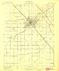 1922 Madera1922 Print · USGSMadera and the surrounding valley floor are captured here in the early twenties, during a period of significant agricultural and infrastructure development. Genealogists and local historians can locate early landmarks like Italian Swiss Colony, the County Hospital, and rural schoolhouses including Lavine School and Arcola School.
End of results
Showing maps 1-4 of 4
Top cities near Madera
Frequently asked questions
- What are the different types of historical maps available for Madera?
- What is the oldest map of Madera?
- Where can I purchase historical maps of Madera for my home or office?
- Where can I download high-res historical maps of Madera?
- Are there historical topographic maps available for Madera?
- Is there historical aerial imagery available for Madera?
- Where are historical maps of Madera sourced from?