1940s Maps of Madera, California
Explore 9 historic maps of Madera from the 1940s. These maps offer a rare glimpse into what life looked like during the 1940s — showing old roads, neighborhoods, homes, and landmarks that have changed or disappeared over time.
Whether you're researching your family's past, planning a metal detecting trip, or studying how Madera's landscape evolved across the 1940s, these high-resolution maps are a powerful tool for exploring the history of this region.
- Focus on a specific era: All maps on this page are from the 1940s, giving you a focused view of this time period.
- See what’s changed: Compare century-old streets, trails, and buildings to today's modern landscape using overlays and satellite layers.
- Research with precision: Use these maps for genealogy, historical research, land use analysis, or educational projects.
- View, download, or print: Maps are fully viewable online in high resolution, and can be downloaded or printed for your own records.
Start exploring Madera's history through authentic maps from the 1940s. This is your window into the past.
Madera, CA maps
(9)- 1946 Map of Le Grand, 1953 Print
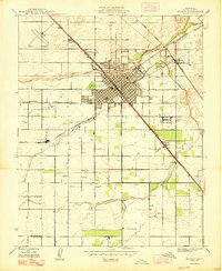
 1946 Le Grand1953 Print · USGSThe San Joaquin Valley agricultural heartland comes into focus during the mid-forties, showing the vital rail corridors and watercourses that shaped the region. Genealogists and local researchers can trace early settlements and rural school sites like Dixieland School, Fairmead, and the northern hub of Le Grand.2 unique versions available
 - 1946 Map of Madera, 1954 Print
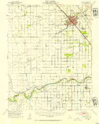 1946 Madera1954 Print · USGSMadera and the surrounding valley floor are shown in the mid-1940s as the regional irrigation network reached its height. Researchers can trace the development of rural education and transport at Storey, Ripperdan School, and the Empire RR.2 unique versions available
 - 1946 Map of Bonita Ranch, 1960 Print
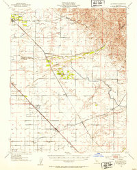
 1946 Bonita Ranch1960 Print · USGSMadera County ranching and irrigation patterns are clearly visible in this mid-century survey of the Central Valley. Researchers can trace the legacy of large operations like Bonita Ranch and the alignment of the Gravelly Ford Canal (Abandoned).
 - 1947 Map of Bonita Ranch
 1947 Bonita Ranch1947 Print · USGSMadera County agricultural life is captured here in the mid-forties, showing the vast ranching and irrigation network of the San Joaquin Valley. Genealogists and researchers can trace local landmarks like Bonita Ranch, the Fresno River, and the Gravelly Ford Canal (Abandoned).
 - 1947 Map of Madera
 1947 Madera1947 Print · USGSMadera was a bustling rail and agricultural hub in the late 1940s, situated where major railroad lines intersected the Central Valley floor. Local historians can trace the foundations of the regional economy at the Madera Winery or locate rural landmarks like La Vina Sch and the settlement of Borden.
 - 1947 Map of San Jose, 1948 Print
 1947 San Jose1948 Print · USGSNorthern California's heartland is captured here just after the war, showing the rapid growth of the Santa Clara and Central Valleys. Researchers can trace the legacy of rail and water at Castle Air Force Base, Stockton, and the Hetch Hetchy Aqueduct.
 - 1948 Map of Santa Cruz
 1948 Santa Cruz1948 Print · USGSThe Central Coast and San Joaquin Valley meet in this mid-century look at the region's agricultural and military geography. Genealogists and historians can trace the paths of El Camino Real, locate family farms near Hollister, or study the footprint of the Fort Ord Military Reservation.2 unique versions available
 - 1948 Map of Kismet
 1948 Kismet1948 Print · USGSMadera County ranchlands and rail corridors come alive in the late 1940s, showing a landscape defined by transit and water. Genealogists and historians can trace the paths of the Southern Pacific through the small settlements of Kismet and Notarb.2 unique versions available
 - 1948 Map of Berenda
 1948 Berenda1948 Print · USGSMadera County agricultural life was at a crossroads in the late 1940s as rail networks and local schools defined the rural landscape. Genealogists can trace family footprints near Dixieland Sch or along the vital Southern Pacific line through Fairmead and Berenda.2 unique versions available
End of results
Showing maps 1-9 of 9
Top cities near Madera
Frequently asked questions
- What are the different types of historical maps available for Madera?
- What is the oldest map of Madera?
- Where can I purchase historical maps of Madera for my home or office?
- Where can I download high-res historical maps of Madera?
- Are there historical topographic maps available for Madera?
- Is there historical aerial imagery available for Madera?
- Where are historical maps of Madera sourced from?