1950s Maps of Anaheim, California
Explore 10 historic maps of Anaheim from the 1950s. These maps offer a rare glimpse into what life looked like during the 1950s — showing old roads, neighborhoods, homes, and landmarks that have changed or disappeared over time.
Whether you're researching your family's past, planning a metal detecting trip, or studying how Anaheim's landscape evolved across the 1950s, these high-resolution maps are a powerful tool for exploring the history of this region.
- Focus on a specific era: All maps on this page are from the 1950s, giving you a focused view of this time period.
- See what’s changed: Compare century-old streets, trails, and buildings to today's modern landscape using overlays and satellite layers.
- Research with precision: Use these maps for genealogy, historical research, land use analysis, or educational projects.
- View, download, or print: Maps are fully viewable online in high resolution, and can be downloaded or printed for your own records.
Start exploring Anaheim's history through authentic maps from the 1950s. This is your window into the past.
Anaheim, CA maps
(10)- 1950 Map of Prado Dam
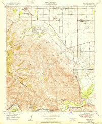 1950 Prado Dam1950 Print · USGSThe Prado Dam area at the start of the 1950s shows a unique mix of institutional expansion, aviation history, and flood control. Local researchers can trace the Cal-Aero Flight Academy, the California Institution for Men, and the Rancho Santa Ana Botanic Gardens.
 - 1950 Map of Yorba Linda
 1950 Yorba Linda1950 Print · USGSMid-century Orange County is caught in a moment of transition between its petroleum roots and growing citrus communities. Genealogists and local historians can trace the early grids of Yorba Linda and Placentia or locate sites like La Vida Mineral Springs and the Olinda Oil Field.
 - 1950 Map of Orange
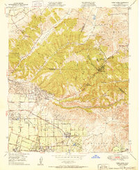
 1950 Orange1950 Print · USGSOrange County enters a period of significant growth at mid-century, where citrus groves meet the expansion of Santa Ana and Orange. Researchers can trace old school sites like Lincoln Sch, numerous Oil Wells, and the Yorba Ch (Aban'd) near the river.
 - 1950 Map of Anaheim
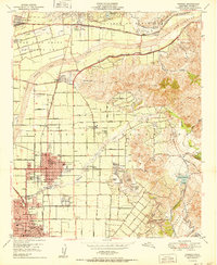
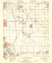
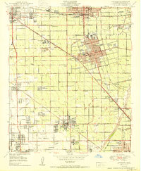 1950 Anaheim1950 Print · USGSPost-war Orange County flourishes here, showing the growth of central citrus hubs before the freeway era. Genealogists can trace family names at Anaheim Cemetery or find historic labor enclaves like Colonia Independencia and Colonia Manzanillo.
 - 1950 Map of Los Alamitos
 1950 Los Alamitos1950 Print · USGSCoastal Southern California is captured here in the mid-century as citrus groves and ranches gave way to defense facilities and new suburbs. Researchers can trace the development of Hawaiian Gardens or locate family history at Artesia Cem and the Pioneer Sch.
 - 1950 Map of Black Star Canyon
 1950 Black Star Canyon1950 Print · USGSThe Orange and Riverside County line was defined by steep canyons and mining prospects at mid-century. Researchers can trace early industrial footprints at the Black Star Coal Mine (Inactive) or locate the Hidden Ranch near the Main Divide Motorway.
 - 1956 Map of Santa Ana
 1956 Santa Ana1956 Print · USGSSouthern California underwent massive mid-century transformation as suburban growth met major military and water projects. Trace the postwar expansion of Santa Ana and Riverside, the layout of Camp Pendleton, and the path of the Colorado River Aqueduct.
 - 1957 Map of Long Beach
 1957 Long Beach1957 Print · USGSThe Los Angeles coast and the Channel Islands appear here during the mid-fifties era of rapid suburbanization and naval expansion. Genealogists and researchers can locate early industrial neighborhoods like South Gate and trace military boundaries at Ft MacArthur Upper Reservation or the remote San Nicolas Island.4 unique versions available
 - 1958 Map of Long Beach
 1958 Long Beach1958 Print · USGSCoastal Southern California is shown during a mid-century period of intense suburbanization and military readiness. Genealogists and historians can trace the growth of Long Beach, identify early neighborhoods in Lakewood Village, or locate the bounds of Ft MacArthur Lower Reservation.
 - 1959 Map of Santa Ana, 1971 Print
 1959 Santa Ana1971 Print · USGSSouthern California is captured in a decade of transformation, from the Orange County coast to the desert floor. Researchers can trace the mid-century footprints of Camp Pendleton, March Air Force Base, and the original Ortega Highway.3 unique versions available
End of results
Showing maps 1-10 of 10
Top cities near Anaheim
- Long Beach historical maps
- Santa Ana historical maps
- Irvine historical maps
- Huntington Beach historical maps
- Ontario historical maps
- Garden Grove historical maps
See more
Top neighborhoods of Anaheim
- Nutwood historical maps
- Neff historical maps
- Friendly Village of Anaheim historical maps
- Yorba historical maps
- Peralta Hills historical maps
- Anaheim Resort District historical maps
See more
Frequently asked questions
- What are the different types of historical maps available for Anaheim?
- What is the oldest map of Anaheim?
- Where can I purchase historical maps of Anaheim for my home or office?
- Where can I download high-res historical maps of Anaheim?
- Are there historical topographic maps available for Anaheim?
- Is there historical aerial imagery available for Anaheim?
- Where are historical maps of Anaheim sourced from?