1960s Maps of Anaheim, California
Explore 9 historic maps of Anaheim from the 1960s. These maps offer a rare glimpse into what life looked like during the 1960s — showing old roads, neighborhoods, homes, and landmarks that have changed or disappeared over time.
Whether you're researching your family's past, planning a metal detecting trip, or studying how Anaheim's landscape evolved across the 1960s, these high-resolution maps are a powerful tool for exploring the history of this region.
- Focus on a specific era: All maps on this page are from the 1960s, giving you a focused view of this time period.
- See what’s changed: Compare century-old streets, trails, and buildings to today's modern landscape using overlays and satellite layers.
- Research with precision: Use these maps for genealogy, historical research, land use analysis, or educational projects.
- View, download, or print: Maps are fully viewable online in high resolution, and can be downloaded or printed for your own records.
Start exploring Anaheim's history through authentic maps from the 1960s. This is your window into the past.
Anaheim, CA maps
(9)- 1960 Map of Long Beach
 1960 Long Beach1960 Print · USGSCoastal California at the height of post-war expansion reveals a dense network of suburban growth and maritime industry. Trace the development of the South Bay and inland neighborhoods like Lakewood Village, or explore the topography of Santa Catalina Island and Los Angeles Harbor.2 unique versions available
 - 1960 Map of Santa Ana
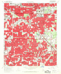
 1960 Santa Ana1960 Print · USGSSouthern California's coastal plains and inland deserts meet in this mid-century survey of the burgeoning Orange and Riverside county corridors. Researchers can trace the layout of early freeway systems, find tribal lands like the Soboba Indian Reservation, and locate military landmarks such as March Field.2 unique versions available
 - 1964 Map of Yorba Linda, 1965 Print
 1964 Yorba Linda1965 Print · USGSOrange County's northern hills were transitioning from oil derricks to suburban neighborhoods in the mid-sixties. Local researchers can trace early school sites like Richard M Nixon Sch, explore the grounds of La Vida Mineral Springs, or locate old landmarks in Sleepy Hollow.3 unique versions available
 - 1964 Map of Los Alamitos, 1966 Print
 1964 Los Alamitos1966 Print · USGSThe Los Angeles and Orange County borderlands thrive during the mid-sixties suburban boom, characterized by massive military installations and new residential tracts. Researchers can locate vanished landmarks and early neighborhood layouts from Dairy Valley to Barber City, alongside the Naval Air Station Los Alamitos.4 unique versions available
 - 1964 Map of Orange, 1966 Print
 1964 Orange1966 Print · USGSMid-century Orange County is caught in a moment of rapid suburban transformation as citrus groves give way to residential grids and new freeways. Genealogists and local researchers can trace the development of established neighborhoods near Chapman College, locate family plots at St Johns Cem, or explore the foothills around Cowan Heights and Irvine Park.5 unique versions available
 - 1965 Map of Santa Ana
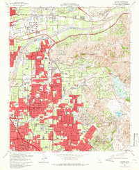
 1965 Santa Ana1965 Print · USGSSouthern California is captured in a decade of rapid growth, showing the coastal expansion from Santa Ana down to Oceanside. Genealogists and historians can trace the mid-century development of places like Garden Grove or the rural reaches of Escondido and the Palomar Observatory.
 - 1965 Map of Anaheim, 1967 Print
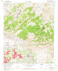
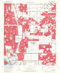
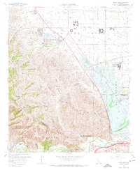
 1965 Anaheim1967 Print · USGSOrange County's rapid mid-century expansion is on full display here, showing the region as it transitioned from agricultural roots to a world-famous entertainment and residential hub. Researchers can trace the early footprints of Disneyland, Knott's Berry Farm, and Anaheim Stadium alongside historic rail lines like the Pacific Electric.3 unique versions available
 - 1967 Map of Black Star Canyon, 1968 Print
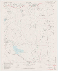 1967 Black Star Canyon1968 Print · USGSThe Santa Ana Mountains in the late sixties reveal a landscape defined by mining operations and new infrastructure. Researchers can trace resource extraction at the Black Star Coal Mine and locate landmarks like Beeks Place or the Rocket Fuel Test Site.7 unique versions available
 - 1967 Map of Prado Dam, 1968 Print
 1967 Prado Dam1968 Print · USGSSan Bernardino County at the height of the 1960s reveals a landscape balancing massive flood control projects with institutional expansion. Trace the historic Yorba Slaughter Adobe and the grounds of Boys Republic near the rising Prado Dam.5 unique versions available
End of results
Showing maps 1-9 of 9
Top cities near Anaheim
- Long Beach historical maps
- Santa Ana historical maps
- Irvine historical maps
- Huntington Beach historical maps
- Ontario historical maps
- Garden Grove historical maps
See more
Top neighborhoods of Anaheim
- Nutwood historical maps
- Neff historical maps
- Friendly Village of Anaheim historical maps
- Yorba historical maps
- Peralta Hills historical maps
- Anaheim Resort District historical maps
See more
Frequently asked questions
- What are the different types of historical maps available for Anaheim?
- What is the oldest map of Anaheim?
- Where can I purchase historical maps of Anaheim for my home or office?
- Where can I download high-res historical maps of Anaheim?
- Are there historical topographic maps available for Anaheim?
- Is there historical aerial imagery available for Anaheim?
- Where are historical maps of Anaheim sourced from?