Old Maps of Garden Grove, California for Academic Research
Study the evolution of Garden Grove with 57 high-resolution historic maps. Whether you're teaching, researching, or modeling changes in land use, these maps provide essential visual documentation of urban, environmental, and geographic change.
- Analyze long-term change: Track patterns in development, transportation, and natural features.
- Ideal for environmental or urban studies: Support academic projects with primary historical map data.
- Use in the classroom or lab: Educators and researchers rely on these maps to bring historical context to life.
These maps are a powerful tool for teaching, research, and visualizing how Garden Grove has changed over the decades.
Garden Grove, CA maps
(57)- 1896 Map of Santa Ana
 1896 Santa Ana1896 Print · USGSOrange County was still a land of vast ranchos and emerging citrus towns in the 1890s, well before the post-war suburban boom. You can trace early rail lines like the SANTA ANA AND NEWPORT R. R. and locate vanished coastal landmarks near Arch Beach and Newport Bay.2 unique versions available
 - 1896 Map of Anaheim
 1896 Anaheim1896 Print · USGSThe Orange County basin appears here in the mid-1890s, when iron rails first connected the young citrus towns to the wider world. Genealogists and researchers can trace the early grids of Anaheim, Fullerton, and Orange alongside now-obscure rail stops like Almond and Marlboro.
 - 1896 Map of Downey
 1896 Downey1896 Print · USGSThe Los Angeles Basin was a landscape of vast ranchos and emerging rail towns in the 1890s. Genealogists and historians can trace the early footprints of Downey and Whittier, alongside unique landmarks like the Poor Farm Sta. and Fulton Wells.
 - 1898 Map of Anaheim, 1899 Print
 1898 Anaheim1899 Print · USGSNorthern Orange County is captured here at the height of its citrus and rail era. Genealogists and local historians can trace the early footprints of Anaheim, Fullerton, and Orange, alongside smaller vanished stops like McPherson and Almond.
 - 1899 Map of Downey
 1899 Downey1899 Print · USGSCoastal Los Angeles County at the close of the nineteenth century reveals a landscape of massive ranchos being carved into early townships. Genealogists can trace family roots through historic rail stops like Obed Bell Sta. and vanished settlements like Spanishtown or Nadeau Park.
 - 1901 Map of Southern California Sheet No. 1
 1901 Southern California Sheet No. 11901 Print · USGSGreater Los Angeles at the dawn of the twentieth century is a landscape of growing citrus towns and a burgeoning rail network. Genealogists and historians can trace the early gridded streets of Hollywood and Pasadena or locate landmarks like Bear Lake and the Cahuilla Indian Reservation.6 unique versions available
 - 1901 Map of Santa Ana
 1901 Santa Ana1901 Print · USGSThe Orange County coast and plains appear here at the dawn of the twentieth century, during a period of agricultural and rail expansion. Genealogists can trace early homesteads near Fairview or locate early rail stops at Smeltzer and Wintersburg.6 unique versions available
 - 1901 Map of Anaheim
 1901 Anaheim1901 Print · USGSOrange County's citrus and rail heartland is meticulously detailed at the start of the century, showing the early layouts of Anaheim and Fullerton. Genealogists can trace early homesteads and rail stops like Loara, Miraflores, and Olinda.6 unique versions available
 - 1902 Map of Downey
 1902 Downey1902 Print · USGSThe Los Angeles coastal plain at the turn of the century shows a network of early citrus towns and Spanish rancho boundaries. Trace the development of the river system and rail stops like Poor Farm Sta., Fulton Wells, and the growing community of Whittier.9 unique versions available
 - 1902 Map of Corona
 1902 Corona1902 Print · USGSThe Orange County and Riverside borderlands at the start of the 1900s show an era of rapid rail expansion and water engineering. Researchers can trace the early footprints of Anaheim and Orange or find vanished industry at the Santiago Coal Mine.7 unique versions available
 - 1904 Map of Southern California Sheet No. 1, 1905 Print
 1904 Southern California Sheet No. 11905 Print · USGSSouthern California at the dawn of the twentieth century shows a landscape of citrus groves and coastal towns connected by rail. Genealogists and historians can trace early settlements like San Juan Capistrano, find remote sites like the Rose Mine, and study the original water systems of the Santa Ana River.2 unique versions available
 - 1932 Map of Newport Beach
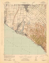
 1932 Newport Beach1932 Print · USGSThe Orange County coast was a landscape of agricultural sidings and early seaside resorts in the early thirties. Trace family history through Colonia Juarez, locate the Balboa Ferry, or find old schoolhouses like Greenville Sch.
 - 1935 Map of Los Alamitos
 1935 Los Alamitos1935 Print · USGSOrange County's coastal plain is captured in the mid-thirties as rural ranch lands began to yield to industrial expansion. Genealogists and researchers can trace early settlements like Los Alamitos and Buena Park or locate landmarks like the Texas Oil Tank Farm.2 unique versions available
 - 1935 Map of Garden Grove
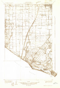
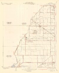
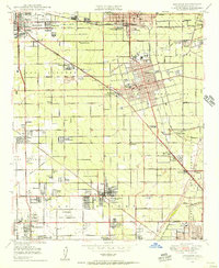
 1935 Garden Grove1935 Print · USGSOrange County's citrus heartland is captured here in the mid-1930s, showing a grid of groves and rail lines. Trace family history at Colonia Manzanillo, find the Anaheim Cem, or locate the old Fullerton Landing Field.3 unique versions available
 - 1935 Map of Newport Beach
 1935 Newport Beach1935 Print · USGSOrange County's coastline and interior plains are captured in the mid-1930s, showing a transition from citrus groves to coastal resorts. Trace the early development of Lido Isle, the sugar beet settlements of Smeltzer, and the tracks of the Pacific Electric.3 unique versions available
 - 1942 Map of Downey
 1942 Downey1942 Print · USGSThe Los Angeles Basin and North Orange County appear here during the wartime boom, showcasing a landscape transitioning from ranchos to suburbs. Trace the historic Pacific Electric rail lines, the oil fields of Santa Fe Springs, and early settlements like Hynes and Studebaker.
 - 1942 Map of Anaheim
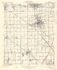
 1942 Anaheim1942 Print · USGSOrange County's agricultural heart is captured mid-century during a period of rapid wartime development. Genealogists can locate family landmarks like Diamond Bar Ranch, local schools such as Alamitos Sch, and communities like Garden Grove or Stanton.2 unique versions available
 - 1942 Map of Santa Ana
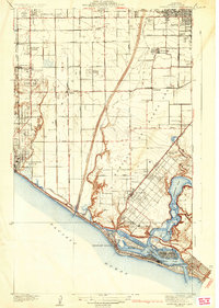
 1942 Santa Ana1942 Print · USGSOrange County was still a landscape of coastal towns and sprawling citrus groves during the early years of the war. Genealogists and researchers can trace the early footprints of Costa Mesa, the rail-side industry of Sugar, and the distinct shorelines of Newport Bay.2 unique versions available
 - 1943 Map of San Pedro
 1943 San Pedro1943 Print · USGSThe South Bay and Los Angeles Harbor area appear here during the Second World War, showing a landscape of burgeoning industry and aviation. Trace wartime infrastructure and local landmarks like Hughes Airport, Terminal Island, and Inglewood Park Cem.
 - 1943 Map of Downey, 1963 Print
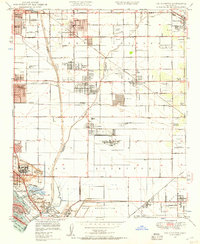
 1943 Downey1963 Print · USGSSoutheast Los Angeles County and northern Orange County appear here at the height of the mid-century boom. Researchers can trace the massive rail infrastructure of the Pacific Electric and locate landmarks like the County Hospital and Signal Hill.2 unique versions available
 - 1947 Map of Santa Ana, 1949 Print
 1947 Santa Ana1949 Print · USGSSouthern California is depicted here in the late forties, showing the expansion of the Inland Empire and the Orange County coast. Researchers can trace the early layout of Palm Springs or locate long-standing tribal lands like the Pala Indian Reservation and Rincon Indian Res.
 - 1949 Map of Long Beach
 1949 Long Beach1949 Print · USGSSouthern California at the start of the post-war boom shows the rapid development of the Los Angeles basin and the South Bay. Genealogists and historians can trace the evolution of early suburbs like Gardena and Lynwood or the coastal defenses at Ft MacArthur Lower Reservation.2 unique versions available
 - 1949 Map of Santa Ana
 1949 Santa Ana1949 Print · USGSSouthern California underwent a profound transformation in the late 1940s as military installations and citrus groves shared the landscape. Researchers can trace early coastal growth at Laguna Beach, military history at Camp Pendleton, and the rail corridors of the Pacific Electric.
 - 1949 Map of Anaheim, 1956 Print
 1949 Anaheim1956 Print · USGSMid-century Orange County is caught in transition from vast groves to suburban centers just before the arrival of major theme parks. Researchers can trace the legacy of local agriculture and early aviation at Haster Field, Colonia Independencia, and the POW Camp (Aband).
 - 1949 Map of Los Alamitos, 1957 Print
 1949 Los Alamitos1957 Print · USGSCoastal California is captured in its post-war transition as old ranch lands give way to suburban growth and aviation. Trace family roots at the Artesia Cem or explore the mid-century industrial footprint of the Naval Reservation and the Oil Tank Farm.2 unique versions available
Showing maps 1-25 of 57
Top cities near Garden Grove
- Los Angeles historical maps
- Long Beach historical maps
- Anaheim historical maps
- Santa Ana historical maps
- Irvine historical maps
- Huntington Beach historical maps
See more
Top neighborhoods of Garden Grove
Frequently asked questions
- What are the different types of historical maps available for Garden Grove?
- What is the oldest map of Garden Grove?
- Where can I purchase historical maps of Garden Grove for my home or office?
- Where can I download high-res historical maps of Garden Grove?
- Are there historical topographic maps available for Garden Grove?
- Is there historical aerial imagery available for Garden Grove?
- Where are historical maps of Garden Grove sourced from?