1940s Maps of Idyllwild-Pine Cove, California
Explore 10 historic maps of Idyllwild-Pine Cove from the 1940s. These maps offer a rare glimpse into what life looked like during the 1940s — showing old roads, neighborhoods, homes, and landmarks that have changed or disappeared over time.
Whether you're researching your family's past, planning a metal detecting trip, or studying how Idyllwild-Pine Cove's landscape evolved across the 1940s, these high-resolution maps are a powerful tool for exploring the history of this region.
- Focus on a specific era: All maps on this page are from the 1940s, giving you a focused view of this time period.
- See what’s changed: Compare century-old streets, trails, and buildings to today's modern landscape using overlays and satellite layers.
- Research with precision: Use these maps for genealogy, historical research, land use analysis, or educational projects.
- View, download, or print: Maps are fully viewable online in high resolution, and can be downloaded or printed for your own records.
Start exploring Idyllwild-Pine Cove's history through authentic maps from the 1940s. This is your window into the past.
Idyllwild-Pine Cove, CA maps
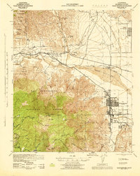
(10)- 1940 Map of Palm Springs, 1955 Print
 1940 Palm Springs1955 Print · USGSPalm Springs and the Coachella Valley are captured here as the mid-century resort era began. Trace the early street grids of Palm Springs, the rail operations at Palm Springs Station, and the boundaries of the Agua Caliente Indian Reservation.
 - 1940 Map of Hemet Reservoir, 1956 Print
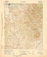
 1940 Hemet Reservoir1956 Print · USGSRiverside County's high-country terrain and tribal lands come into focus in this mid-century survey of the San Jacinto area. Genealogists and researchers can trace old ranch trails and remote sites like Anza, Keen Camp, and the Gold Shot Mine.
 - 1942 Map of Banning, 1943 Print
 1942 Banning1943 Print · USGSRiverside County at the start of the 1940s centers on the critical rail and road artery through the San Gorgonio Pass. Genealogists and historians can locate family holdings like Browns Ranch or trace local landmarks such as Gilman Hot Springs and the St Boniface Indian Sch.2 unique versions available
 - 1942 Map of Hemet Reservoir, 1943 Print
 1942 Hemet Reservoir1943 Print · USGSRiverside County ranching and mountain life are captured here in the early nineteen-forties, spanning from high alpine ridges down to the valley floors. Researchers can locate family outposts like Garner Ranch, the Gold Shot Mine, and the Hamilton School.
 - 1942 Map of Hemet, 1952 Print
 1942 Hemet1952 Print · USGSRiverside County during the early 1940s shows the growth of Hemet alongside the high-country ranching and mining of the Coahuila Indian Reservation. Researchers can trace old mountain routes like Gibbel Road and find remote sites such as the San Ignacio Sch.2 unique versions available
 - 1943 Map of Hemet
 1943 Hemet1943 Print · USGSThe San Jacinto Valley and surrounding peaks appear here during the Second World War as a blend of valley agriculture and mountain forest. Researchers can trace early school sites like Little Lake Sch, the Coahuila Indian Reservation, and the Williamson Mine.
 - 1943 Map of Banning, 1952 Print
 1943 Banning1952 Print · USGSRiverside County at the height of the Second World War shows the critical transportation and resort corridor through the San Gorgonio Pass. Researchers can trace the legacy of the St Boniface Indian Sch and the development of Highland Springs Resort alongside the Southern Pacific rail line.
 - 1944 Map of Palm Springs
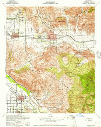
 1944 Palm Springs1944 Print · USGSIn the mid-1940s, the desert resort of Palm Springs was still a compact settlement bordered by the Agua Caliente Indian Reservation. Genealogists and researchers can trace the early rail stops at Garnet and Palm Springs Station, or locate mountain retreats like Fern Valley and Pine Cove Camp.
 - 1947 Map of Santa Ana, 1949 Print
 1947 Santa Ana1949 Print · USGSSouthern California is depicted here in the late forties, showing the expansion of the Inland Empire and the Orange County coast. Researchers can trace the early layout of Palm Springs or locate long-standing tribal lands like the Pala Indian Reservation and Rincon Indian Res.
 - 1949 Map of Santa Ana
 1949 Santa Ana1949 Print · USGSSouthern California underwent a profound transformation in the late 1940s as military installations and citrus groves shared the landscape. Researchers can trace early coastal growth at Laguna Beach, military history at Camp Pendleton, and the rail corridors of the Pacific Electric.
End of results
Showing maps 1-10 of 10
Top cities near Idyllwild-Pine Cove
- Hemet historical maps
- Cathedral City historical maps
- San Jacinto historical maps
- Palm Springs historical maps
- Banning historical maps
- Beaumont historical maps
See more
Top neighborhoods of Idyllwild-Pine Cove
Frequently asked questions
- What are the different types of historical maps available for Idyllwild-Pine Cove?
- What is the oldest map of Idyllwild-Pine Cove?
- Where can I purchase historical maps of Idyllwild-Pine Cove for my home or office?
- Where can I download high-res historical maps of Idyllwild-Pine Cove?
- Are there historical topographic maps available for Idyllwild-Pine Cove?
- Is there historical aerial imagery available for Idyllwild-Pine Cove?
- Where are historical maps of Idyllwild-Pine Cove sourced from?