1950s Maps of Idyllwild-Pine Cove, California
Explore 7 historic maps of Idyllwild-Pine Cove from the 1950s. These maps offer a rare glimpse into what life looked like during the 1950s — showing old roads, neighborhoods, homes, and landmarks that have changed or disappeared over time.
Whether you're researching your family's past, planning a metal detecting trip, or studying how Idyllwild-Pine Cove's landscape evolved across the 1950s, these high-resolution maps are a powerful tool for exploring the history of this region.
- Focus on a specific era: All maps on this page are from the 1950s, giving you a focused view of this time period.
- See what’s changed: Compare century-old streets, trails, and buildings to today's modern landscape using overlays and satellite layers.
- Research with precision: Use these maps for genealogy, historical research, land use analysis, or educational projects.
- View, download, or print: Maps are fully viewable online in high resolution, and can be downloaded or printed for your own records.
Start exploring Idyllwild-Pine Cove's history through authentic maps from the 1950s. This is your window into the past.
Idyllwild-Pine Cove, CA maps
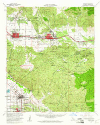
(7)- 1956 Map of Santa Ana
 1956 Santa Ana1956 Print · USGSSouthern California underwent massive mid-century transformation as suburban growth met major military and water projects. Trace the postwar expansion of Santa Ana and Riverside, the layout of Camp Pendleton, and the path of the Colorado River Aqueduct.
 - 1956 Map of Lake Fulmor, 1957 Print
 1956 Lake Fulmor1957 Print · USGSRiverside County’s mountain retreats are captured here in the mid-fifties, showing the high-country flats and forest outposts. Trace the locations of early social landmarks like Twin Pines Ranch, Trailfinders Camp, and the Vista Grande Guard Station.5 unique versions available
 - 1956 Map of Banning, 1961 Print
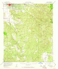
 1956 Banning1961 Print · USGSRiverside County towns and mountain passes are captured here during the mid-1950s. Genealogists and historians can trace the development of Banning, San Jacinto, and Beaumont while locating landmarks like St Boniface Sch and Sunnyslope Cem.2 unique versions available
 - 1957 Map of Hemet, 1960 Print
 1957 Hemet1960 Print · USGSRiverside County at mid-century reveals a landscape of growing valley towns like Hemet and agricultural ranches bordering the national forest. Researchers can trace rural life through the San Ignacio School, the Williamson Mine, and the Atchison Topeka and Santa Fe rail line.3 unique versions available
 - 1957 Map of Palm Springs, 1960 Print
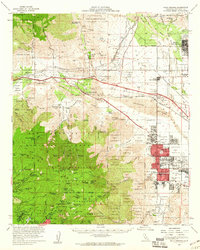 1957 Palm Springs1960 Print · USGSPalm Springs and the San Jacinto peaks are captured here in the late fifties, showing the desert resort's mid-century expansion. Researchers can locate established landmarks like the White Water PO, trace old mountain retreats at Laws Camp, and see early desert schools like Coffman Sch.4 unique versions available
 - 1959 Map of Idyllwild, 1961 Print
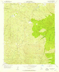
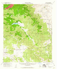 1959 Idyllwild1961 Print · USGSThe high San Jacinto peaks and ranchlands of Riverside County are captured here in the late fifties. Genealogists and local historians can trace family properties like Fleming Ranch or locate the Lucky Deer Mine and the Hamilton Sch.3 unique versions available
 - 1959 Map of Santa Ana, 1971 Print
 1959 Santa Ana1971 Print · USGSSouthern California is captured in a decade of transformation, from the Orange County coast to the desert floor. Researchers can trace the mid-century footprints of Camp Pendleton, March Air Force Base, and the original Ortega Highway.3 unique versions available
End of results
Showing maps 1-7 of 7
Top cities near Idyllwild-Pine Cove
- Hemet historical maps
- Cathedral City historical maps
- San Jacinto historical maps
- Palm Springs historical maps
- Banning historical maps
- Beaumont historical maps
See more
Top neighborhoods of Idyllwild-Pine Cove
Frequently asked questions
- What are the different types of historical maps available for Idyllwild-Pine Cove?
- What is the oldest map of Idyllwild-Pine Cove?
- Where can I purchase historical maps of Idyllwild-Pine Cove for my home or office?
- Where can I download high-res historical maps of Idyllwild-Pine Cove?
- Are there historical topographic maps available for Idyllwild-Pine Cove?
- Is there historical aerial imagery available for Idyllwild-Pine Cove?
- Where are historical maps of Idyllwild-Pine Cove sourced from?