1990s Maps of Idyllwild-Pine Cove, California
Explore 4 historic maps of Idyllwild-Pine Cove from the 1990s. These maps offer a rare glimpse into what life looked like during the 1990s — showing old roads, neighborhoods, homes, and landmarks that have changed or disappeared over time.
Whether you're researching your family's past, planning a metal detecting trip, or studying how Idyllwild-Pine Cove's landscape evolved across the 1990s, these high-resolution maps are a powerful tool for exploring the history of this region.
- Focus on a specific era: All maps on this page are from the 1990s, giving you a focused view of this time period.
- See what’s changed: Compare century-old streets, trails, and buildings to today's modern landscape using overlays and satellite layers.
- Research with precision: Use these maps for genealogy, historical research, land use analysis, or educational projects.
- View, download, or print: Maps are fully viewable online in high resolution, and can be downloaded or printed for your own records.
Start exploring Idyllwild-Pine Cove's history through authentic maps from the 1990s. This is your window into the past.
Idyllwild-Pine Cove, CA maps
(4)- 1996 Map of Idyllwild, 1999 Print
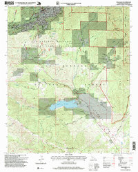 1996 Idyllwild1999 Print · USGSIdyllwild and the high San Jacinto peaks are shown in the mid-1990s as a thriving mountain community and conservation zone. Researchers can trace land use at Lake Hemet, locate local institutions like the Desert Sun School, and find old homesteads like Fleming Ranch.
 - 1996 Map of Blackburn Canyon, 1999 Print
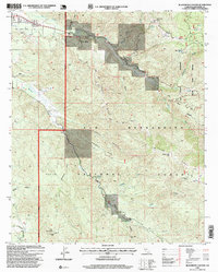 1996 Blackburn Canyon1999 Print · USGSRiverside County’s high country comes into focus in the mid-nineties, showing the rugged intersection of the San Jacinto River and Bautista Creek. Genealogists and hikers can trace old routes like the Toll Road or locate landmarks such as Cranston, Alvin Meadow, and Hixon Flat.
 - 1996 Map of Lake Fulmor, 1999 Print
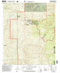 1996 Lake Fulmor1999 Print · USGSIn the San Jacinto Mountains during the 1990s, this area showcases a landscape of high ridges and specialized ranch outposts. Researchers can trace the remote roads leading to Twin Pines Ranch, Mount Oak Boys Ranch, and the waters of Lake Fulmor.
 - 1996 Map of San Jacinto Peak, 1999 Print
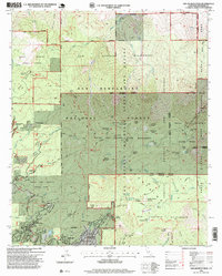 1996 San Jacinto Peak1999 Print · USGSThe San Jacinto Mountains in the mid-nineties are a haven of high-country retreats and deep wilderness. Trace the development of Idyllwild and Pine Cove or explore the network of trails leading to San Jacinto Peak, Lily Rock, and Tahquitz Meadow.
End of results
Showing maps 1-4 of 4
Top cities near Idyllwild-Pine Cove
- Hemet historical maps
- Cathedral City historical maps
- San Jacinto historical maps
- Palm Springs historical maps
- Banning historical maps
- Beaumont historical maps
See more
Top neighborhoods of Idyllwild-Pine Cove
Frequently asked questions
- What are the different types of historical maps available for Idyllwild-Pine Cove?
- What is the oldest map of Idyllwild-Pine Cove?
- Where can I purchase historical maps of Idyllwild-Pine Cove for my home or office?
- Where can I download high-res historical maps of Idyllwild-Pine Cove?
- Are there historical topographic maps available for Idyllwild-Pine Cove?
- Is there historical aerial imagery available for Idyllwild-Pine Cove?
- Where are historical maps of Idyllwild-Pine Cove sourced from?