1900s (20th Century) Maps of Rancho Dos Palmas, California
Explore 13 historic maps of Rancho Dos Palmas from the 1900s (20th Century). These maps offer a rare glimpse into what life looked like during the 1900s — showing old roads, neighborhoods, homes, and landmarks that have changed or disappeared over time.
Whether you're researching your family's past, planning a metal detecting trip, or studying how Rancho Dos Palmas's landscape evolved across the 1900s, these high-resolution maps are a powerful tool for exploring the history of this region.
- Focus on a specific era: All maps on this page are from the 1900s, giving you a focused view of this time period.
- See what’s changed: Compare century-old streets, trails, and buildings to today's modern landscape using overlays and satellite layers.
- Research with precision: Use these maps for genealogy, historical research, land use analysis, or educational projects.
- View, download, or print: Maps are fully viewable online in high resolution, and can be downloaded or printed for your own records.
Start exploring Rancho Dos Palmas's history through authentic maps from the 1900s. This is your window into the past.
Rancho Dos Palmas, CA maps
(13)- 1940 Map of Durmid, 1964 Print
 1940 Durmid1964 Print · USGSImperial County and the desert shoreline of the Salton Sea appear here in the early 1940s, just as new water infrastructure reached the area. Researchers can trace the Southern Pacific rail line through Durmid and Bertram or follow the early Anza Trail past Truckhaven.
 - 1944 Map of Durmid
 1944 Durmid1944 Print · USGSImperial County was a landscape of extreme elevations and vital rail connections during the mid-forties. Researchers can trace the desert outposts of Truckhaven and Durmid alongside the Southern Pacific line and the Truckhaven Trail.
 - 1954 Map of Salton Sea
 1954 Salton Sea1954 Print · USGSThe Colorado River and Imperial Valley desert frontiers are captured here in the 1950s. Trace the irrigation networks of Calipatria and mining sites like Eagle Mountain Mine.
 - 1955 Map of Salton Sea
 1955 Salton Sea1955 Print · USGSThe Colorado River and Imperial Valley desert basins appear here during the mid-fifties, revealing a landscape of remote mines and agricultural irrigation. Genealogists and researchers can trace locations like the Parker Alien Reception Center Unit No 1, Blythe, and the Kane Springs School.2 unique versions available
 - 1956 Map of Durmid, 1957 Print
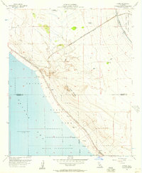 1956 Durmid1957 Print · USGSThe Salton Sea shoreline in the mid-fifties shows a remote desert landscape shaped by rail and water management. Trace the rail sidings at Ferrum and Durmid, or explore the grounds of Rancho Dos Palmas and the Bertram Mine.3 unique versions available
 - 1957 Map of Durmid
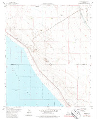
 1957 Durmid1957 Print · USGSThe Salton Sea shoreline and the Southern Pacific rail line define this California desert landscape in the mid-1940s. Genealogists and historians can trace small settlements and infrastructure like Truckhaven, Salton Beach, and the Torres-Martinez Indian Res.
 - 1959 Map of Salton Sea, 1968 Print
 1959 Salton Sea1968 Print · USGSThe Colorado River and Salton Sea basin are shown here during a decade of intense military and agricultural activity. Trace family roots in Blythe or Niland, and locate historical mining operations like the Eagle Mountain Mine and Red Cloud Mine.4 unique versions available
 - 1963 Map of Salton Sea
 1963 Salton Sea1963 Print · USGSThe Colorado Desert during the early sixties shows a landscape defined by massive water projects and Cold War military ranges. Trace the growth of Salton City and Brawley, or locate remote desert outposts like the Paymaster Mine and Desert Center.
 - 1965 Map of Salton Sea
 1965 Salton Sea1965 Print · USGSThe Colorado Desert and Imperial Valley are caught in a period of intense irrigation and military expansion during the mid-sixties. Researchers can trace the desert's industrial footprint through the Eagle Mountain Mine, the remote Desert Center, and the Salton Sea Test Base.
 - 1978 Map of Durmid, 1987 Print
 1978 Durmid1987 Print · USGSThe desert shoreline of the Salton Sea in the late seventies reveals a landscape of industrial transit and military boundaries. Researchers can trace the Southern Pacific rail stops at Ferrum and Durmid, or locate the remote Bertram Mine near the county line.
 - 1985 Map of Salton Sea
 1985 Salton Sea1985 Print · USGSIn the mid-1980s, the California desert around the Salton Sea shows a unique mix of military gunnery ranges, irrigated agriculture, and shoreline settlements. Trace the Southern Pacific rail route through Niland and Bombay Beach, or locate remote desert sites like the Black Eagle Mine.2 unique versions available
 - 1992 Map of Durmid, 1995 Print
 1992 Durmid1995 Print · USGSThe Salton Sea shoreline in the early nineties reveals a rugged landscape of military ranges and desert industry. Trace the Mining Railway toward the Bertram Mine or locate historic water sites at Rancho Dos Palmas.
 - 1998 Map of Durmid, 2002 Print
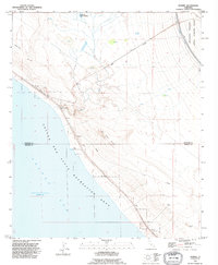
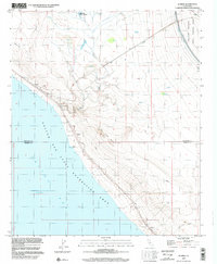 1998 Durmid2002 Print · USGSThe Salton Sea shoreline and the harsh desert of the Imperial Valley are captured here in the late 1990s. Researchers can trace the desert Railway corridor through Ferrum or locate remote sites like Rancho Dos Palmas and Bertram Mine.
End of results
Showing maps 1-13 of 13
Top cities near Rancho Dos Palmas
Frequently asked questions
- What are the different types of historical maps available for Rancho Dos Palmas?
- What is the oldest map of Rancho Dos Palmas?
- Where can I purchase historical maps of Rancho Dos Palmas for my home or office?
- Where can I download high-res historical maps of Rancho Dos Palmas?
- Are there historical topographic maps available for Rancho Dos Palmas?
- Is there historical aerial imagery available for Rancho Dos Palmas?
- Where are historical maps of Rancho Dos Palmas sourced from?