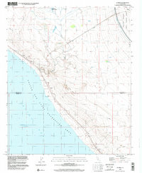
1998 Map of Durmid
USGS Topo · Published 2002About this map
The Salton Sea State Recreation Area shoreline dominates this desert landscape, revealing a stark industrial and recreational geography at the end of the 20th century. Along the northeastern edge of the water, the Railway and a parallel Pipeline cut through the arid terrain, connecting small settlements like Ferrum, Durmid, and Bertram. This corridor represents a vital infrastructure link through the Colorado Desert, where water management is visible through the massive Coachella Canal and its associated Levee system in the northeast.
Find a feature on this map
27 named features on this map. Tap any name to fly to it.
Don’t see what you’re looking for? This feature index may not catch every label — zoom into the map to look around manually.
Map Details
Editions of this 1998 Durmid Map
This is the sole edition of this map. No revisions or reprints were ever made.
Other maps of this area

1940 · Frink
USGS Topo · 1:62,500

1940 · Cottonwood Spring
USGS Topo · 1:62,500

1940 · Canyon Spring
USGS Topo · 1:62,500

1940 · Durmid
USGS Topo · 1:62,500

1943 · Canyon Spring
USGS Topo · 1:62,500

1944 · Cottonwood Spring
USGS Topo · 1:62,500

1944 · Durmid
USGS Topo · 1:62,500

1944 · Frink
USGS Topo · 1:62,500

1954 · Salton Sea
USGS Topo · 1:250,000

1955 · Salton Sea
USGS Topo · 1:250,000