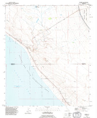
1992 Map of Durmid
USGS Topo · Published 1995About this map
The Salton Sea dominates the southwestern portion of this map, its shoreline marked by the Salton Sea State Recreation Area and specialized infrastructure like a Boat Ramp and Gaging Sta. The landscape reflects a mix of desert recreation and heavy industry, where the Mining Railway and an extensive Pipeline network crisscross the arid terrain. Settlements are sparse but strategic, including Ferrum, Durmid, and Bertram, which are positioned along the rail corridor.
Find a feature on this map
24 named features on this map. Tap any name to fly to it.
Don’t see what you’re looking for? This feature index may not catch every label — zoom into the map to look around manually.
Map Details
Editions of this 1992 Durmid Map
This is the sole edition of this map. No revisions or reprints were ever made.
Other maps of this area

1940 · Frink
USGS Topo · 1:62,500

1940 · Cottonwood Spring
USGS Topo · 1:62,500

1940 · Canyon Spring
USGS Topo · 1:62,500

1940 · Durmid
USGS Topo · 1:62,500

1943 · Canyon Spring
USGS Topo · 1:62,500

1944 · Cottonwood Spring
USGS Topo · 1:62,500

1944 · Durmid
USGS Topo · 1:62,500

1944 · Frink
USGS Topo · 1:62,500

1954 · Salton Sea
USGS Topo · 1:250,000

1955 · Salton Sea
USGS Topo · 1:250,000