Old Maps of Folsom, California
Explore 20 old maps of Folsom, spanning from 1891 to today. These high-resolution historic maps reveal how streets, neighborhoods, landmarks, and natural features evolved over time — perfect for genealogy, metal detecting, research, and local history exploration.
What you can do with these maps:
- See how Folsom changed over time: Compare historical maps to modern-day views to trace roads, homesites, rail lines & more.
- View detailed metadata: Each map includes creators, publishers, year, scale, and archive source.
- Overlay maps with satellite & LiDAR: Visualize the past alongside modern tools to explore terrain & human change.
- Trusted historical sources: Maps sourced from the USGS, Library of Congress, and other archives.
- Access maps your way: View online, download high-res files, or order prints for personal or research use.
Start exploring old maps of Folsom to uncover forgotten places, hidden landmarks, and the deep history beneath your feet.
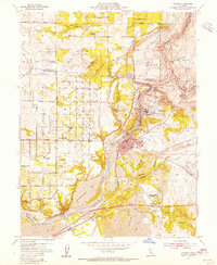
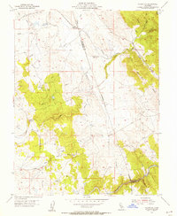
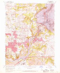
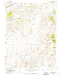
Folsom, CA maps
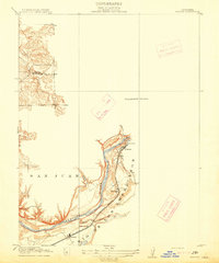
(20)- 1891 Map of Sacramento
 1891 Sacramento1891 Print · USGSCovers Folsom, including Sacramento, Roseville, and other nearby areas
 - 1892 Map of Sacramento
 1892 Sacramento1892 Print · USGSCovers Folsom, including Sacramento, Roseville, and other nearby areas5 unique versions available
 - 1893 Map of Sacramento, 1900 Print
 1893 Sacramento1900 Print · USGSCovers Folsom, including Sacramento, Roseville, and other nearby areas
 - 1908 Map of Buffalo Creek
 1908 Buffalo Creek1908 Print · USGSCovers Folsom, including Rancho Cordova, Sacramento County, and other nearby areas
 - 1914 Map of Folsom
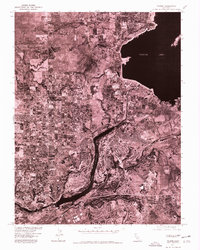
 1914 Folsom1914 Print · USGSCovers Folsom, including Roseville, Citrus Heights, and other nearby areas2 unique versions available
 - 1916 Map of Buffalo Creek
 1916 Buffalo Creek1916 Print · USGSCovers Folsom, including Rancho Cordova, Sacramento County, and other nearby areas2 unique versions available
 - 1941 Map of Folsom, 1957 Print
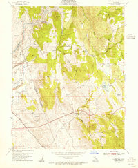
 1941 Folsom1957 Print · USGSCovers Folsom, including Roseville, Citrus Heights, and other nearby areas2 unique versions available
 - 1944 Map of Folsom
 1944 Folsom1944 Print · USGSCovers Folsom, including Roseville, Citrus Heights, and other nearby areas2 unique versions available
 - 1947 Map of Sacramento, 1948 Print
 1947 Sacramento1948 Print · USGSCovers Folsom, including Sacramento, Stockton, and other nearby areas2 unique versions available
 - 1948 Map of Sacramento, 1951 Print
 1948 Sacramento1951 Print · USGSCovers Folsom, including Sacramento, Stockton, and other nearby areas
 - 1953 Map of Clarksville, 1955 Print
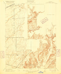
 1953 Clarksville1955 Print · USGSCovers Folsom, including El Dorado Hills, Cambridge Oaks, and other nearby areas7 unique versions available
 - 1954 Map of Buffalo Creek, 1955 Print
 1954 Buffalo Creek1955 Print · USGSCovers Folsom, including Rancho Cordova, Sacramento County, and other nearby areas2 unique versions available
 - 1954 Map of Folsom, 1955 Print
 1954 Folsom1955 Print · USGSCovers Folsom, including Roseville, Citrus Heights, and other nearby areas2 unique versions available
 - 1954 Map of Folsom SE, 1955 Print
 1954 Folsom SE1955 Print · USGSCovers Folsom, including El Dorado Hills, Walltown, and other nearby areas5 unique versions available
 - 1956 Map of Sacramento
 1956 Sacramento1956 Print · USGSCovers Folsom, including Sacramento, Stockton, and other nearby areas2 unique versions available
 - 1957 Map of Sacramento, 1966 Print
 1957 Sacramento1966 Print · USGSCovers Folsom, including Sacramento, Stockton, and other nearby areas4 unique versions available
 - 1967 Map of Folsom, 1968 Print
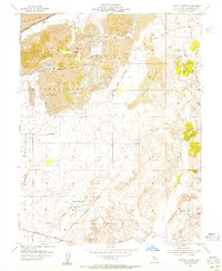
 1967 Folsom1968 Print · USGSCovers Folsom, including Roseville, Citrus Heights, and other nearby areas4 unique versions available
 - 1967 Map of Buffalo Creek, 1968 Print
 1967 Buffalo Creek1968 Print · USGSCovers Folsom, including Rancho Cordova, Sacramento County, and other nearby areas6 unique versions available
 - 1975 Map of Folsom, 1978 Print
 1975 Folsom1978 Print · USGSCovers Folsom, including Roseville, Citrus Heights, and other nearby areas
 - 1994 Map of Sacramento
 1994 Sacramento1994 Print · USGSCovers Folsom, including Sacramento, Roseville, and other nearby areas2 unique versions available
End of results
Showing maps 1-20 of 20
Top cities near Folsom
- Sacramento historical maps
- Roseville historical maps
- Citrus Heights historical maps
- Rancho Cordova historical maps
- Rocklin historical maps
- El Dorado Hills historical maps
See more
Top neighborhoods of Folsom
- White Rock historical maps
- Folsom Junction historical maps
- Natoma historical maps
- Represa historical maps
- Prairie Oaks historical maps
- The Parkway historical maps
See more
Frequently asked questions
- What are the different types of historical maps available for Folsom?
- What is the oldest map of Folsom?
- Where can I purchase historical maps of Folsom for my home or office?
- Where can I download high-res historical maps of Folsom?
- Are there historical topographic maps available for Folsom?
- Is there historical aerial imagery available for Folsom?
- Where are historical maps of Folsom sourced from?