1960s Maps of Folsom, California
Explore 2 historic maps of Folsom from the 1960s. These maps offer a rare glimpse into what life looked like during the 1960s — showing old roads, neighborhoods, homes, and landmarks that have changed or disappeared over time.
Whether you're researching your family's past, planning a metal detecting trip, or studying how Folsom's landscape evolved across the 1960s, these high-resolution maps are a powerful tool for exploring the history of this region.
- Focus on a specific era: All maps on this page are from the 1960s, giving you a focused view of this time period.
- See what’s changed: Compare century-old streets, trails, and buildings to today's modern landscape using overlays and satellite layers.
- Research with precision: Use these maps for genealogy, historical research, land use analysis, or educational projects.
- View, download, or print: Maps are fully viewable online in high resolution, and can be downloaded or printed for your own records.
Start exploring Folsom's history through authentic maps from the 1960s. This is your window into the past.
Folsom, CA maps
(2)- 1967 Map of Folsom, 1968 Print
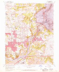 1967 Folsom1968 Print · USGSThe American River corridor was undergoing rapid transformation in the late sixties as suburban growth met industrial history. Researchers can locate Folsom State Prison, trace the old Prairie City (Site), and see the extensive Dredge Tailings left from gold mining days.4 unique versions available
 - 1967 Map of Buffalo Creek, 1968 Print
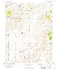 1967 Buffalo Creek1968 Print · USGSSacramento County in the late sixties shows a landscape transformed by gold dredging and military expansion. Genealogists and researchers can trace the margins of Mather Air Force Base, find the Frye settlement, or locate Carson Creek High Sch among the expansive dredge tailings.6 unique versions available
End of results
Showing maps 1-2 of 2
Top cities near Folsom
- Sacramento historical maps
- Roseville historical maps
- Citrus Heights historical maps
- Rancho Cordova historical maps
- Rocklin historical maps
- El Dorado Hills historical maps
See more
Top neighborhoods of Folsom
- Folsom Junction historical maps
- Natoma historical maps
- White Rock historical maps
- Represa historical maps
- Prairie Oaks historical maps
- Folsom Meadows historical maps
See more
Frequently asked questions
- What are the different types of historical maps available for Folsom?
- What is the oldest map of Folsom?
- Where can I purchase historical maps of Folsom for my home or office?
- Where can I download high-res historical maps of Folsom?
- Are there historical topographic maps available for Folsom?
- Is there historical aerial imagery available for Folsom?
- Where are historical maps of Folsom sourced from?