1950s Maps of Folsom, California
Explore 6 historic maps of Folsom from the 1950s. These maps offer a rare glimpse into what life looked like during the 1950s — showing old roads, neighborhoods, homes, and landmarks that have changed or disappeared over time.
Whether you're researching your family's past, planning a metal detecting trip, or studying how Folsom's landscape evolved across the 1950s, these high-resolution maps are a powerful tool for exploring the history of this region.
- Focus on a specific era: All maps on this page are from the 1950s, giving you a focused view of this time period.
- See what’s changed: Compare century-old streets, trails, and buildings to today's modern landscape using overlays and satellite layers.
- Research with precision: Use these maps for genealogy, historical research, land use analysis, or educational projects.
- View, download, or print: Maps are fully viewable online in high resolution, and can be downloaded or printed for your own records.
Start exploring Folsom's history through authentic maps from the 1950s. This is your window into the past.
Folsom, CA maps
(6)- 1953 Map of Clarksville, 1955 Print
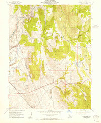 1953 Clarksville1955 Print · USGSEl Dorado County was undergoing a major transformation in the mid-1950s as the Folsom Reservoir project began to submerge the local landscape. Genealogists and historians can locate the Live Oak Sch, trace the Southern Pacific rail line, and find old settlements like Clarksville.7 unique versions available
 - 1954 Map of Buffalo Creek, 1955 Print
 1954 Buffalo Creek1955 Print · USGSSacramento County in the mid-1950s shows a landscape still defined by gold-era industry and large land grants. Researchers can trace the massive Dredge Tailings near the Southern Pacific tracks or locate the Blodgett Reservoir and old windmill sites.2 unique versions available
 - 1954 Map of Folsom, 1955 Print
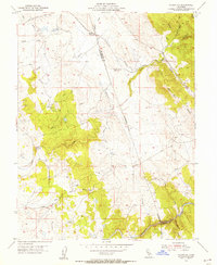
 1954 Folsom1955 Print · USGSThe American River region undergoes a massive transformation in the mid-fifties as the new Folsom and Nimbus dams begin to reshape the valley. Genealogists and historians can trace the foundations of Orangevale or find the soon-to-be-submerged Mormon Island (Site) and Prairie City (Site).2 unique versions available
 - 1954 Map of Folsom SE, 1955 Print
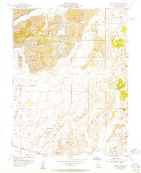
 1954 Folsom SE1955 Print · USGSThe Gold Country foothills of Sacramento and El Dorado counties are shown here during the mid-1950s. Genealogists and historians can trace old mining sites near Walltown, the path of the Southern Pacific, and the Carson Creek Sch (Aban'd).5 unique versions available
 - 1956 Map of Sacramento
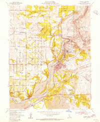
 1956 Sacramento1956 Print · USGSMid-century California unfolds from the delta to the high Sierra, capturing a landscape of growing valley cities and burgeoning military airbases. Genealogists and historians can trace the rail lines and river towns from Woodland to Lodi, or explore the foothill settlements of Placerville and Jackson.2 unique versions available
 - 1957 Map of Sacramento, 1966 Print
 1957 Sacramento1966 Print · USGSIn the mid-twentieth century, the California heartland was a hub of river transport, rail lines, and military airbases. Genealogists and historians can trace the development of Gold Country towns like Angels Camp and Sonora or follow the path of the Southern Pacific RR through the growing suburbs of Sacramento.4 unique versions available
End of results
Showing maps 1-6 of 6
Top cities near Folsom
- Sacramento historical maps
- Roseville historical maps
- Citrus Heights historical maps
- Rancho Cordova historical maps
- Rocklin historical maps
- El Dorado Hills historical maps
See more
Top neighborhoods of Folsom
- Folsom Junction historical maps
- Natoma historical maps
- White Rock historical maps
- Represa historical maps
- Prairie Oaks historical maps
- Folsom Meadows historical maps
See more
Frequently asked questions
- What are the different types of historical maps available for Folsom?
- What is the oldest map of Folsom?
- Where can I purchase historical maps of Folsom for my home or office?
- Where can I download high-res historical maps of Folsom?
- Are there historical topographic maps available for Folsom?
- Is there historical aerial imagery available for Folsom?
- Where are historical maps of Folsom sourced from?