1970s Maps of Daggett, California
Explore 3 historic maps of Daggett from the 1970s. These maps offer a rare glimpse into what life looked like during the 1970s — showing old roads, neighborhoods, homes, and landmarks that have changed or disappeared over time.
Whether you're researching your family's past, planning a metal detecting trip, or studying how Daggett's landscape evolved across the 1970s, these high-resolution maps are a powerful tool for exploring the history of this region.
- Focus on a specific era: All maps on this page are from the 1970s, giving you a focused view of this time period.
- See what’s changed: Compare century-old streets, trails, and buildings to today's modern landscape using overlays and satellite layers.
- Research with precision: Use these maps for genealogy, historical research, land use analysis, or educational projects.
- View, download, or print: Maps are fully viewable online in high resolution, and can be downloaded or printed for your own records.
Start exploring Daggett's history through authentic maps from the 1970s. This is your window into the past.
Daggett, CA maps
(3)- 1971 Map of Daggett, 1973 Print
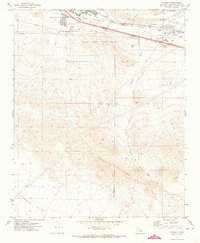 1971 Daggett1973 Print · USGSThe high desert around the Mojave River in the early seventies shows a landscape of military logistics and rail transit. Researchers can find the McKinney Sch, Daggett Cem, and the sprawling Marine Corps Supply Center.2 unique versions available
 - 1971 Map of Minneola, 1973 Print
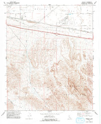 1971 Minneola1973 Print · USGSThe Mojave high desert during the early seventies reveals a landscape defined by Route 66 and mountain mining. Trace the historic National Trails Highway past Minneola, locate the Azucar Mine in the hills, or study the Barstow Daggett Airport.2 unique versions available
 - 1977 Map of Newberry Springs, 1993 Print
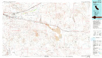 1977 Newberry Springs1993 Print · USGSThe Mojave High Desert in the late seventies is shown here as a landscape of railroads and mining. Researchers can trace the legacy of remote camps and transport hubs like Stedman, Ragtown, and the busy Barstow-Daggett Airport.
End of results
Showing maps 1-3 of 3
Top cities near Daggett
Frequently asked questions
- What are the different types of historical maps available for Daggett?
- What is the oldest map of Daggett?
- Where can I purchase historical maps of Daggett for my home or office?
- Where can I download high-res historical maps of Daggett?
- Are there historical topographic maps available for Daggett?
- Is there historical aerial imagery available for Daggett?
- Where are historical maps of Daggett sourced from?