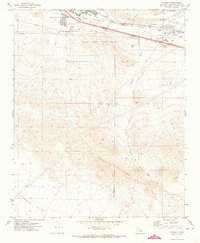
1971 Map of Daggett
USGS Topo · Published 1973About this map
Daggett serves as a critical desert junction where the Atchison Topeka and Santa Fe railroad tracks parallel the Mojave River through the Mojave Valley. The early 1970s landscape is defined by a significant military footprint, including the Marine Corps Supply Center and the extensive Marine Corps Firing Range, which stretches toward the high ground of Daggett Ridge.
Find a feature on this map
19 named features on this map. Tap any name to fly to it.
Don’t see what you’re looking for? This feature index may not catch every label — zoom into the map to look around manually.
Map Details
Editions of this 1971 Daggett Map
2 editions found
Other maps of this area

1932 · Barstow
USGS Topo · 1:125,000

1934 · Barstow
USGS Topo · 1:125,000

1953 · San Bernardino
USGS Topo · 1:250,000

1953 · Yermo
USGS Topo · 1:24,000
1953 · Nebo
USGS Topo · 1:24,000

1955 · Ord Mountains
USGS Topo · 1:62,500

1956 · San Bernardino
USGS Topo · 1:250,000

1956 · Daggett
USGS Topo · 1:62,500

1956 · Barstow
USGS Topo · 1:62,500

1957 · Apple Valley
USGS Topo · 1:62,500