1990s Maps of Twentynine Palms, California
Explore 3 historic maps of Twentynine Palms from the 1990s. These maps offer a rare glimpse into what life looked like during the 1990s — showing old roads, neighborhoods, homes, and landmarks that have changed or disappeared over time.
Whether you're researching your family's past, planning a metal detecting trip, or studying how Twentynine Palms's landscape evolved across the 1990s, these high-resolution maps are a powerful tool for exploring the history of this region.
- Focus on a specific era: All maps on this page are from the 1990s, giving you a focused view of this time period.
- See what’s changed: Compare century-old streets, trails, and buildings to today's modern landscape using overlays and satellite layers.
- Research with precision: Use these maps for genealogy, historical research, land use analysis, or educational projects.
- View, download, or print: Maps are fully viewable online in high resolution, and can be downloaded or printed for your own records.
Start exploring Twentynine Palms's history through authentic maps from the 1990s. This is your window into the past.
Twentynine Palms, CA maps
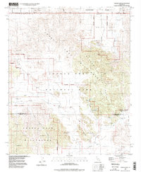
(3)- 1995 Map of Queen Mountain, 1998 Print
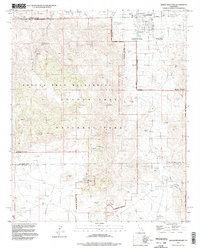 1995 Queen Mountain1998 Print · USGSThe Mojave Desert highlands come to life in the mid-nineties, showing the intersection of mining history and park conservation. Trace old claims at the Desert Queen Mine or Anaconda Mine and locate vanished habitations at Pine City (Site).2 unique versions available
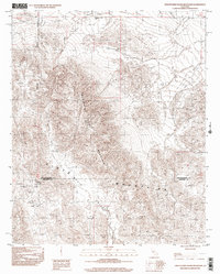
 - 1995 Map of Indian Cove, 1998 Print
 1995 Indian Cove1998 Print · USGSThe High Desert landscape near Twentynine Palms is shown in the mid-nineties, capturing the intersection of early mining history and modern conservation. Researchers can locate historic sites like the Wall Street Mill, the Lang Mine, and ancient Petroglyphs.2 unique versions available
 - 1997 Map of Twentynine Palms Mountain, 2002 Print
 1997 Twentynine Palms Mountain2002 Print · USGSThe high desert at the San Bernardino and Riverside county line is documented here in the late nineties. Mineral seekers and historians can trace numerous workings like the North Star Mine, Goat Basin Mine, and the settlement of Gold Park.
End of results
Showing maps 1-3 of 3
Top neighborhoods of Twentynine Palms
Frequently asked questions
- What are the different types of historical maps available for Twentynine Palms?
- What is the oldest map of Twentynine Palms?
- Where can I purchase historical maps of Twentynine Palms for my home or office?
- Where can I download high-res historical maps of Twentynine Palms?
- Are there historical topographic maps available for Twentynine Palms?
- Is there historical aerial imagery available for Twentynine Palms?
- Where are historical maps of Twentynine Palms sourced from?