1990s Maps of Victorville, California
Explore 1 historic maps of Victorville from the 1990s. These maps offer a rare glimpse into what life looked like during the 1990s — showing old roads, neighborhoods, homes, and landmarks that have changed or disappeared over time.
Whether you're researching your family's past, planning a metal detecting trip, or studying how Victorville's landscape evolved across the 1990s, these high-resolution maps are a powerful tool for exploring the history of this region.
- Focus on a specific era: All maps on this page are from the 1990s, giving you a focused view of this time period.
- See what’s changed: Compare century-old streets, trails, and buildings to today's modern landscape using overlays and satellite layers.
- Research with precision: Use these maps for genealogy, historical research, land use analysis, or educational projects.
- View, download, or print: Maps are fully viewable online in high resolution, and can be downloaded or printed for your own records.
Start exploring Victorville's history through authentic maps from the 1990s. This is your window into the past.
Victorville, CA maps
(1)- 1996 Map of Baldy Mesa, 1999 Print
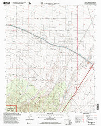 1996 Baldy Mesa1999 Print · USGSThe High Desert region south of Victorville is captured here in the mid-1990s as suburban growth began to meet traditional ranching lands. Genealogists and local historians can trace family-named sites like Fish Ranch and White Ranch near the San Bernardino National Forest boundary.
End of results
Showing maps 1-1 of 1
Top cities near Victorville
- Hesperia historical maps
- Apple Valley historical maps
- Adelanto historical maps
- Oak Hills historical maps
- Piñon Hills historical maps
Top neighborhoods of Victorville
- Bellevue Heights historical maps
- The Village historical maps
- Eagle Ranch historical maps
- Duncan Corners historical maps
- Sunset Ridge historical maps
- Golden Mesa historical maps
See more
Frequently asked questions
- What are the different types of historical maps available for Victorville?
- What is the oldest map of Victorville?
- Where can I purchase historical maps of Victorville for my home or office?
- Where can I download high-res historical maps of Victorville?
- Are there historical topographic maps available for Victorville?
- Is there historical aerial imagery available for Victorville?
- Where are historical maps of Victorville sourced from?