1950s Maps of Santee, California
Explore 8 historic maps of Santee from the 1950s. These maps offer a rare glimpse into what life looked like during the 1950s — showing old roads, neighborhoods, homes, and landmarks that have changed or disappeared over time.
Whether you're researching your family's past, planning a metal detecting trip, or studying how Santee's landscape evolved across the 1950s, these high-resolution maps are a powerful tool for exploring the history of this region.
- Focus on a specific era: All maps on this page are from the 1950s, giving you a focused view of this time period.
- See what’s changed: Compare century-old streets, trails, and buildings to today's modern landscape using overlays and satellite layers.
- Research with precision: Use these maps for genealogy, historical research, land use analysis, or educational projects.
- View, download, or print: Maps are fully viewable online in high resolution, and can be downloaded or printed for your own records.
Start exploring Santee's history through authentic maps from the 1950s. This is your window into the past.
Santee, CA maps
(8)- 1950 Map of San Diego, 1954 Print
 1950 San Diego1954 Print · USGSCoastal San Diego and the Baja California border region come alive in this mid-century survey. Trace the early layout of National City and Chula Vista, or locate historic landmarks like the San Diego and Arizona Eastern RR and Fort Rosecrans.
 - 1952 Map of Poway Valley, 1954 Print
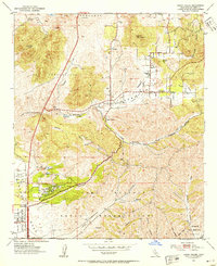 1952 Poway Valley1954 Print · USGSThe Poway Valley of the early fifties is captured here as a rural landscape beginning its transition into a major suburban and military hub. Genealogists and local historians can trace early school sites like Pomerado Sch and Midland Sch alongside the expansive Miramar Naval Air Station Reservation.3 unique versions available
 - 1953 Map of La Mesa, 1955 Print
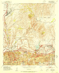 1953 La Mesa1955 Print · USGSThe eastern edge of San Diego and La Mesa are captured during a period of mid-century suburban expansion. Genealogists and local historians can trace neighborhood growth through San Diego State College and local schools like Hoover High Sch.3 unique versions available
 - 1954 Map of San Diego
 1954 San Diego1954 Print · USGSSan Diego and the northern reaches of Baja California are captured here during a decade of rapid post-war growth and military expansion. Researchers can trace the mid-century shoreline of Mission Beach, find established tribal lands like Capitan Grande Indian Reservation, and follow the border crossing into Tijuana.
 - 1955 Map of San Diego
 1955 San Diego1955 Print · USGSSouthern California underwent massive growth in the post-war years, as suburban development pushed into the canyons and foothills. Researchers can trace the mid-century infrastructure of Lindbergh Field, the Otay River, and numerous sites like Lemon Grove.
 - 1955 Map of San Vicente Reservoir, 1956 Print
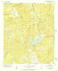 1955 San Vicente Reservoir1956 Print · USGSSan Diego's backcountry in the mid-1950s is defined by its deep canyons and the early footprints of major water infrastructure. Local historians can trace family landholdings like Goodan Ranch and Wildwood Ranch alongside the vast Camp Elliott Naval Reservation.4 unique versions available
 - 1955 Map of El Cajon, 1956 Print
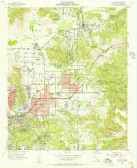 1955 El Cajon1956 Print · USGSEl Cajon and the San Diego River valley are shown here in the mid-fifties, capturing a period of suburban growth among established ranches. Researchers can trace the San Diego and Arizona Eastern RR, locate the El Cajon Cemetery, or find long-standing landmarks like GILLESPIE FIELD.2 unique versions available
 - 1958 Map of San Diego, 1961 Print
 1958 San Diego1961 Print · USGSSan Diego and its inland mountain ranges are captured here in the late fifties as coastal suburbs began to climb the mesas. Researchers can trace the mid-century footprint of Miramar Naval Air Station, the winding San Diego & Arizona Eastern Ry, and local landmarks like Cabrillo Nat Mon.4 unique versions available
End of results
Showing maps 1-8 of 8
Top cities near Santee
- San Diego historical maps
- Chula Vista historical maps
- Escondido historical maps
- El Cajon historical maps
- San Marcos historical maps
- Encinitas historical maps
See more
Top neighborhoods of Santee
Frequently asked questions
- What are the different types of historical maps available for Santee?
- What is the oldest map of Santee?
- Where can I purchase historical maps of Santee for my home or office?
- Where can I download high-res historical maps of Santee?
- Are there historical topographic maps available for Santee?
- Is there historical aerial imagery available for Santee?
- Where are historical maps of Santee sourced from?