1990s Maps of Santee, California
Explore 4 historic maps of Santee from the 1990s. These maps offer a rare glimpse into what life looked like during the 1990s — showing old roads, neighborhoods, homes, and landmarks that have changed or disappeared over time.
Whether you're researching your family's past, planning a metal detecting trip, or studying how Santee's landscape evolved across the 1990s, these high-resolution maps are a powerful tool for exploring the history of this region.
- Focus on a specific era: All maps on this page are from the 1990s, giving you a focused view of this time period.
- See what’s changed: Compare century-old streets, trails, and buildings to today's modern landscape using overlays and satellite layers.
- Research with precision: Use these maps for genealogy, historical research, land use analysis, or educational projects.
- View, download, or print: Maps are fully viewable online in high resolution, and can be downloaded or printed for your own records.
Start exploring Santee's history through authentic maps from the 1990s. This is your window into the past.
Santee, CA maps
(4)- 1994 Map of La Mesa, 1998 Print
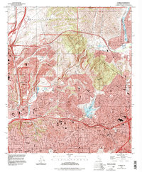 1994 La Mesa1998 Print · USGSSan Diego and La Mesa undergo significant mid-century suburban expansion as military and educational institutions anchor the landscape. Trace local development near San Diego State University, the historic Mission San Diego de Alcala, and Lake Murray.
 - 1996 Map of San Vicente Reservoir, 2001 Print
 1996 San Vicente Reservoir2001 Print · USGSSan Diego County's inland valleys and rugged highlands are captured here in the late nineties as residential growth met preserved ranch lands. Researchers can trace the bounds of the Miramar Sycamore Canyon Annex or locate historic homesteads at Goodan Ranch and Fernbrook.
 - 1996 Map of El Cajon, 2001 Print
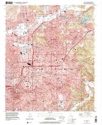 1996 El Cajon2001 Print · USGSThe valleys of East County were well-established suburban hubs by the late nineties. Genealogists and local historians can trace family-named sites and landmarks like Edgemoor Hospital, Cajon Speedway, and Lindo Lake.
 - 1996 Map of Poway, 2001 Print
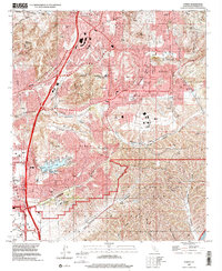 1996 Poway2001 Print · USGSPoway and the northern reaches of San Diego are shown here during the suburban expansion of the late nineties. Genealogists and local historians can trace the development of Scripps Ranch, find local schools like Pomerado Sch, or locate family sites at Dearborn Memorial Park.
End of results
Showing maps 1-4 of 4
Top cities near Santee
- San Diego historical maps
- Chula Vista historical maps
- Escondido historical maps
- El Cajon historical maps
- San Marcos historical maps
- Encinitas historical maps
See more
Top neighborhoods of Santee
Frequently asked questions
- What are the different types of historical maps available for Santee?
- What is the oldest map of Santee?
- Where can I purchase historical maps of Santee for my home or office?
- Where can I download high-res historical maps of Santee?
- Are there historical topographic maps available for Santee?
- Is there historical aerial imagery available for Santee?
- Where are historical maps of Santee sourced from?