1910s Maps of Escalon, California
Explore 2 historic maps of Escalon from the 1910s. These maps offer a rare glimpse into what life looked like during the 1910s — showing old roads, neighborhoods, homes, and landmarks that have changed or disappeared over time.
Whether you're researching your family's past, planning a metal detecting trip, or studying how Escalon's landscape evolved across the 1910s, these high-resolution maps are a powerful tool for exploring the history of this region.
- Focus on a specific era: All maps on this page are from the 1910s, giving you a focused view of this time period.
- See what’s changed: Compare century-old streets, trails, and buildings to today's modern landscape using overlays and satellite layers.
- Research with precision: Use these maps for genealogy, historical research, land use analysis, or educational projects.
- View, download, or print: Maps are fully viewable online in high resolution, and can be downloaded or printed for your own records.
Start exploring Escalon's history through authentic maps from the 1910s. This is your window into the past.
Escalon, CA maps
(2)- 1914 Map of Avena
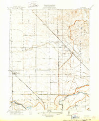
 1914 Avena1914 Print · USGSThe San Joaquin Valley comes into focus just before World War I as irrigation began to reshape the landscape. Genealogists and historians can trace old homesteads near Avena and Atlanta or locate rural school sites like Van Allen School and Four Tree School.
 - 1915 Map of Thalheim
 1915 Thalheim1915 Print · USGSThe Central Valley's burgeoning irrigation and rail networks are captured here during a period of rapid agricultural expansion. Researchers can trace the development of early settlements like Thalheim and Escalon alongside rural landmarks such as Burwood School and the Thompson Rancho.2 unique versions available
End of results
Showing maps 1-2 of 2
Top cities near Escalon
- Stockton historical maps
- Modesto historical maps
- Manteca historical maps
- Ceres historical maps
- Riverbank historical maps
- Oakdale historical maps
See more
Frequently asked questions
- What are the different types of historical maps available for Escalon?
- What is the oldest map of Escalon?
- Where can I purchase historical maps of Escalon for my home or office?
- Where can I download high-res historical maps of Escalon?
- Are there historical topographic maps available for Escalon?
- Is there historical aerial imagery available for Escalon?
- Where are historical maps of Escalon sourced from?