1910s Maps of Ripon, California
Explore 4 historic maps of Ripon from the 1910s. These maps offer a rare glimpse into what life looked like during the 1910s — showing old roads, neighborhoods, homes, and landmarks that have changed or disappeared over time.
Whether you're researching your family's past, planning a metal detecting trip, or studying how Ripon's landscape evolved across the 1910s, these high-resolution maps are a powerful tool for exploring the history of this region.
- Focus on a specific era: All maps on this page are from the 1910s, giving you a focused view of this time period.
- See what’s changed: Compare century-old streets, trails, and buildings to today's modern landscape using overlays and satellite layers.
- Research with precision: Use these maps for genealogy, historical research, land use analysis, or educational projects.
- View, download, or print: Maps are fully viewable online in high resolution, and can be downloaded or printed for your own records.
Start exploring Ripon's history through authentic maps from the 1910s. This is your window into the past.
Ripon, CA maps
(4)- 1914 Map of Manteca
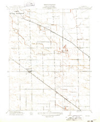 1914 Manteca1914 Print · USGSSan Joaquin County agriculture is in full bloom during the early twentieth century as irrigation transforms the valley floor. Genealogists can locate family-named landmarks like Castle School and Atlanta Church or trace the early paths of the Tidewater Southern Road.2 unique versions available
 - 1914 Map of Avena
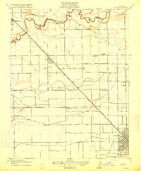
 1914 Avena1914 Print · USGSThe San Joaquin Valley comes into focus just before World War I as irrigation began to reshape the landscape. Genealogists and historians can trace old homesteads near Avena and Atlanta or locate rural school sites like Van Allen School and Four Tree School.
 - 1915 Map of Ripon
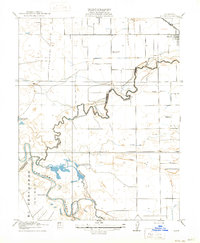 1915 Ripon1915 Print · USGSRipon and the San Joaquin Valley river bottoms are captured here during the height of early twentieth-century agricultural development. Genealogists and researchers can trace local landmarks like Jackson School, the S. P. R. R. (Fresno Line), and the Owl Rod and Gun Club.2 unique versions available
 - 1915 Map of Salida
 1915 Salida1915 Print · USGSThe fertile plains north of Modesto are captured here just before the First World War, showing a landscape transformed by complex irrigation. Genealogists can locate family homesteads near rural landmarks like Wood Colony School or along the Southern Pacific tracks in Salida.2 unique versions available
End of results
Showing maps 1-4 of 4
Top cities near Ripon
- Stockton historical maps
- Modesto historical maps
- Manteca historical maps
- Turlock historical maps
- Ceres historical maps
- Riverbank historical maps
See more
Top neighborhoods of Ripon
Frequently asked questions
- What are the different types of historical maps available for Ripon?
- What is the oldest map of Ripon?
- Where can I purchase historical maps of Ripon for my home or office?
- Where can I download high-res historical maps of Ripon?
- Are there historical topographic maps available for Ripon?
- Is there historical aerial imagery available for Ripon?
- Where are historical maps of Ripon sourced from?