
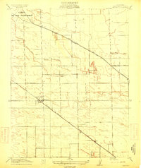
1914 Map of Manteca
USGS Topo · Published 1914About this map
Manteca stands as a budding agricultural hub at the crossroads of the Central Valley during this 1914 survey. The landscape is defined by the intersection of major rail corridors, including the Tidewater Southern Road and the Southern Pacific (Fresno Line), which facilitated the movement of goods and people across San Joaquin County. This era captures the transition of the former Campo de los Franceses land grant into a modern farming district, supported by the extensive South San Joaquin Irrigation District Ditch.
Find a feature on this map
16 named features on this map. Tap any name to fly to it.
Don’t see what you’re looking for? This feature index may not catch every label — zoom into the map to look around manually.
Map Details
Editions of this 1914 Manteca Map
2 editions found
Other maps of this area

1913 · Stockton
USGS Topo · 1:31,680

1914 · Burnham
USGS Topo · 1:31,680

1914 · Avena
USGS Topo · 1:31,680

1915 · Vernalis
USGS Topo · 1:31,680

1915 · Lathrop
USGS Topo · 1:31,680

1915 · Ripon
USGS Topo · 1:31,680

1915 · Peters
USGS Topo · 1:31,680

1915 · Salida
USGS Topo · 1:31,680

1922 · Carbona
USGS Topo · 1:62,500
1941 · Modesto West
USGS Topo · 1:62,500