
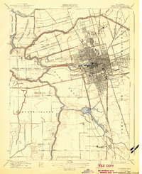
1913 Map of Stockton
USGS Topo · Published 1913About this map
Stockton serves as the focal point of this pre-war survey, revealing a dense urban grid surrounded by an intricate network of waterways and reclaimed agricultural tracts. The map illustrates the city's heavy reliance on its waterfront, with the Stockton Channel and Mormon Slough providing vital access for commerce. Along the San Joaquin River and its various branches, numerous family-named river landings such as Barnhart Landing, Calaveras Landing, and Delfino Landing highlight the early 20th-century dependence on waterborne transport for the surrounding levee-protected lands like Roberts Island and the Weber Tract.
Find a feature on this map
48 named features on this map. Tap any name to fly to it.
Don’t see what you’re looking for? This feature index may not catch every label — zoom into the map to look around manually.
Map Details
Editions of this 1913 Stockton Map
2 editions found
Other maps of this area

1894 · Lodi
USGS Topo · 1:125,000

1908 · Waterloo
USGS Topo · 1:31,680

1910 · Castle
USGS Topo · 1:31,680

1910 · Headreach
USGS Topo · 1:31,680

1913 · Holt
USGS Topo · 1:31,680

1914 · Burnham
USGS Topo · 1:31,680

1914 · Manteca
USGS Topo · 1:31,680

1914 · Union Island
USGS Topo · 1:31,680

1915 · Lathrop
USGS Topo · 1:31,680
1939 · Lodi
USGS Topo · 1:62,500