
1915 Map of Ripon
USGS Topo · Published 1915About this map
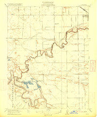
The Stanislaus River and San Joaquin River converge in this 1915 survey, defining a landscape of complex waterways and early irrigation efforts. The settlement of Ripon is positioned in the northeast corner along the S. P. R. R. (Fresno Line), serving as a rail-dependent hub for the surrounding agricultural tracts. The map reveals an intricate network of water management features, including a Pumping Plant and several irrigation canals such as Lateral No 6 and Lateral No 7, illustrating the transformation of the Central Valley into productive farmland.
Find a feature on this map
19 named features on this map. Tap any name to fly to it.
Don’t see what you’re looking for? This feature index may not catch every label — zoom into the map to look around manually.
Map Details
Editions of this 1915 Ripon Map
2 editions found
Other maps of this area

1913 · Romain
USGS Topo · 1:31,680

1914 · Manteca
USGS Topo · 1:31,680

1914 · Avena
USGS Topo · 1:31,680

1915 · Vernalis
USGS Topo · 1:31,680

1915 · Lathrop
USGS Topo · 1:31,680

1915 · Westport
USGS Topo · 1:31,680

1915 · Westley
USGS Topo · 1:31,680

1915 · Salida
USGS Topo · 1:31,680

1916 · Romain
USGS Topo · 1:31,680

1922 · Carbona
USGS Topo · 1:62,500