
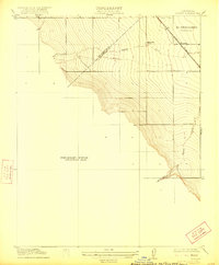
1916 Map of Romain
USGS Topo · Published 1916About this map
El Pescadero (Grimes) terrain dominates this 1916 survey, where the foothills of the Coast Range meet the agricultural flats of the Central Valley. The map captures a moment of early development along the Southern Pacific rail line, which passes through the small settlement of Romain. The landscape is defined by the drainage patterns of Hospital Creek and Ingram Creek, which carve through the rising elevation to the west. Evidence of early infrastructure is sparse but specific, including the Concrete Bridge over Ingram Creek and the Rising Sun School situated near the county line. The survey clearly delineates the boundary between San Joaquin Co and Stanislaus Co, following the break in the terrain. This preliminary edition provides a clear record of the area's rural character before the intensification of modern irrigation and expanded transportation networks changed the San Joaquin Valley floor.
Find a feature on this map
9 named features on this map. Tap any name to fly to it.
Don’t see what you’re looking for? This feature index may not catch every label — zoom into the map to look around manually.
Map Details
Editions of this 1916 Romain Map
2 editions found
Other maps of this area

1913 · Romain
USGS Topo · 1:31,680

1915 · Vernalis
USGS Topo · 1:31,680

1915 · Ripon
USGS Topo · 1:31,680

1915 · Westley
USGS Topo · 1:31,680

1916 · Patterson
USGS Topo · 1:31,680

1916 · Tracy
USGS Topo · 1:31,680

1919 · Orestimba
USGS Topo · 1:62,500

1922 · Carbona
USGS Topo · 1:62,500

1938 · Mt. Boardman
USGS Topo · 1:62,500

1941 · Orestimba
USGS Topo · 1:62,500