
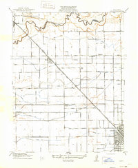
1915 Map of Salida
USGS Topo · Published 1915About this map
The Stanislaus River defines the northern boundary of this agricultural landscape, marking the line between San Joaquin and Stanislaus counties. The interior reveals a highly organized irrigation network, featuring the Main Canal and various numbered laterals such as Lateral No 6 and Lateral No 7 that supported the region's early 20th-century orchard and field development. The rail-centered growth of the era is evident where the Southern Pacific (Fresno Line) bisects the town of Salida, while the Tidewater Southern railway services the eastern edge near Standiford. A grid of country schools, including Wood Colony School, Stanislaus School, and Hart School, serves the rural farming population, while the expanding northern blocks of Modesto anchor the southeastern corner of the survey.
Find a feature on this map
23 named features on this map. Tap any name to fly to it.
Don’t see what you’re looking for? This feature index may not catch every label — zoom into the map to look around manually.
Map Details
Editions of this 1915 Salida Map
2 editions found
Other maps of this area

1914 · Manteca
USGS Topo · 1:31,680

1914 · Avena
USGS Topo · 1:31,680

1915 · Ripon
USGS Topo · 1:31,680

1915 · Westport
USGS Topo · 1:31,680

1915 · Westley
USGS Topo · 1:31,680

1915 · Thalheim
USGS Topo · 1:31,680

1916 · Riverbank
USGS Topo · 1:31,680

1916 · Ceres
USGS Topo · 1:31,680

1939 · Modesto East
USGS Topo · 1:62,500
1941 · Modesto West
USGS Topo · 1:62,500