1960s Maps of Stockton, California
Explore 5 historic maps of Stockton from the 1960s. These maps offer a rare glimpse into what life looked like during the 1960s — showing old roads, neighborhoods, homes, and landmarks that have changed or disappeared over time.
Whether you're researching your family's past, planning a metal detecting trip, or studying how Stockton's landscape evolved across the 1960s, these high-resolution maps are a powerful tool for exploring the history of this region.
- Focus on a specific era: All maps on this page are from the 1960s, giving you a focused view of this time period.
- See what’s changed: Compare century-old streets, trails, and buildings to today's modern landscape using overlays and satellite layers.
- Research with precision: Use these maps for genealogy, historical research, land use analysis, or educational projects.
- View, download, or print: Maps are fully viewable online in high resolution, and can be downloaded or printed for your own records.
Start exploring Stockton's history through authentic maps from the 1960s. This is your window into the past.
Stockton, CA maps
(5)- 1962 Map of San Jose
 1962 San Jose1962 Print · USGSCentral California in the early sixties showcases the expansion of the San Joaquin and Santa Clara valleys. Researchers can trace the rail-to-road transition along the Southern Pacific RR or locate landmarks like Castle USAF Base and Loma Prieta.4 unique versions available
 - 1966 Map of San Jose
 1966 San Jose1966 Print · USGSCentral California in the mid-1960s reveals a landscape of massive irrigation projects and expanding Cold War military footprints. Researchers can trace the rail-and-river network of the San Joaquin Valley or locate specialized sites like Castle Air Force Base and the Sharp General Depot (Military).
 - 1968 Map of Stockton East, 1969 Print
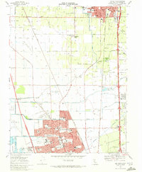
 1968 Stockton East1969 Print · USGSStockton and its eastern agricultural fringes are captured here in the late sixties, showing a landscape defined by heavy rail and water engineering. Researchers can trace the mid-century footprint of Sharpe Army Depot and local landmarks like Garden Acres and the Northern California Youth Center.4 unique versions available
 - 1968 Map of Stockton West, 1970 Print
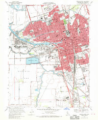 1968 Stockton West1970 Print · USGSMid-century Stockton emerges as a bustling hub of river commerce and rail traffic at the height of its post-war growth. Genealogists and local historians can trace family locations near the Rural Cemetery, the The Homestead settlement, and numerous historic schools like Fairchild Sch.3 unique versions available
 - 1968 Map of Lodi South, 1972 Print
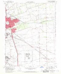
 1968 Lodi South1972 Print · USGSThe agricultural heart of San Joaquin County is captured here in the late sixties as suburban expansion reaches northward from Stockton. Trace family roots and local history through features like Lodi Academy, Henderson Village, and the Micke Grove County Park.3 unique versions available
End of results
Showing maps 1-5 of 5
Top cities near Stockton
- Tracy historical maps
- Manteca historical maps
- Lodi historical maps
- Lathrop historical maps
- Ripon historical maps
Top neighborhoods of Stockton
- El Pinal historical maps
- The Homestead historical maps
- Fair Oaks historical maps
- Mormon historical maps
- Ortega historical maps
- Akers historical maps
See more
Frequently asked questions
- What are the different types of historical maps available for Stockton?
- What is the oldest map of Stockton?
- Where can I purchase historical maps of Stockton for my home or office?
- Where can I download high-res historical maps of Stockton?
- Are there historical topographic maps available for Stockton?
- Is there historical aerial imagery available for Stockton?
- Where are historical maps of Stockton sourced from?