1990s Maps of Stockton, California
Explore 2 historic maps of Stockton from the 1990s. These maps offer a rare glimpse into what life looked like during the 1990s — showing old roads, neighborhoods, homes, and landmarks that have changed or disappeared over time.
Whether you're researching your family's past, planning a metal detecting trip, or studying how Stockton's landscape evolved across the 1990s, these high-resolution maps are a powerful tool for exploring the history of this region.
- Focus on a specific era: All maps on this page are from the 1990s, giving you a focused view of this time period.
- See what’s changed: Compare century-old streets, trails, and buildings to today's modern landscape using overlays and satellite layers.
- Research with precision: Use these maps for genealogy, historical research, land use analysis, or educational projects.
- View, download, or print: Maps are fully viewable online in high resolution, and can be downloaded or printed for your own records.
Start exploring Stockton's history through authentic maps from the 1990s. This is your window into the past.
Stockton, CA maps
(2)- 1993 Map of Lodi, 1994 Print
 1993 Lodi1994 Print · USGSNorthern California's delta country and the growing Central Valley corridors are captured here in the early nineties. Genealogists and historians can trace the intricate island tracts, old railroad lines like the Sacramento Northern RR, and established local landmarks including the Lodi Memorial Cemetery and University of the Pacific.2 unique versions available
 - 1997 Map of Terminous, 2002 Print
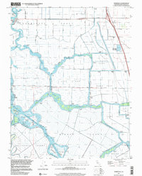 1997 Terminous2002 Print · USGSThe California Delta's intricate network of reclaimed lands and channels is captured here in the late nineties. Genealogists and researchers can trace local landmarks like Terminous, the Venice King Sch, and family-named lands such as the Rindge Tract.
End of results
Showing maps 1-2 of 2
Top cities near Stockton
- Tracy historical maps
- Manteca historical maps
- Lodi historical maps
- Lathrop historical maps
- Ripon historical maps
Top neighborhoods of Stockton
- El Pinal historical maps
- The Homestead historical maps
- Fair Oaks historical maps
- Mormon historical maps
- Ortega historical maps
- Akers historical maps
See more
Frequently asked questions
- What are the different types of historical maps available for Stockton?
- What is the oldest map of Stockton?
- Where can I purchase historical maps of Stockton for my home or office?
- Where can I download high-res historical maps of Stockton?
- Are there historical topographic maps available for Stockton?
- Is there historical aerial imagery available for Stockton?
- Where are historical maps of Stockton sourced from?