2020s Maps of Stockton, California
Explore 5 historic maps of Stockton from the 2020s. These maps offer a rare glimpse into what life looked like during the 2020s — showing old roads, neighborhoods, homes, and landmarks that have changed or disappeared over time.
Whether you're researching your family's past, planning a metal detecting trip, or studying how Stockton's landscape evolved across the 2020s, these high-resolution maps are a powerful tool for exploring the history of this region.
- Focus on a specific era: All maps on this page are from the 2020s, giving you a focused view of this time period.
- See what’s changed: Compare century-old streets, trails, and buildings to today's modern landscape using overlays and satellite layers.
- Research with precision: Use these maps for genealogy, historical research, land use analysis, or educational projects.
- View, download, or print: Maps are fully viewable online in high resolution, and can be downloaded or printed for your own records.
Start exploring Stockton's history through authentic maps from the 2020s. This is your window into the past.
Stockton, CA maps
(5)- 2021 Map of Stockton West, 2021 Print
 2021 Stockton West2021 Print · USGSThe Port of Stockton and its surrounding delta lands are captured in this 2021 survey, showing a landscape defined by deep-water channels and major river forks. Researchers can trace historic neighborhoods like The Homestead and August alongside several local cemeteries such as Stockton Rural Cem and Hebrew Cem.
 - 2021 Map of Stockton East, 2021 Print
 2021 Stockton East2021 Print · USGSThe eastern edges of the San Joaquin Valley meet the rising urban sprawl of the early twenty-first century. Genealogists and local researchers can trace family landmarks and rural communities from Collegeville and the Collegeville Cem to the early industrial corridors near Stockton.
 - 2021 Map of Holt, 2021 Print
 2021 Holt2021 Print · USGSThe California Delta west of Stockton comes alive in this contemporary survey of reclaimed islands and intricate waterways. Trace the path of the Mokelumne Aqueduct as it passes near Holt and search the shores of Windmill Cove or Whiskey Slough for local landmarks.
 - 2021 Map of Terminous, 2021 Print
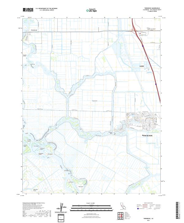 2021 Terminous2021 Print · USGSThe San Joaquin Delta at the start of the 2020s shows a complex web of islands and industrial waterways. Researchers can trace the levee-lined borders of Bouldin Island and King Island or locate points like Paradise Point and Terminous.
 - 2021 Map of Lodi South, 2021 Print
 2021 Lodi South2021 Print · USGSSan Joaquin County comes into focus in this recent look at the corridor between Stockton and Lodi. Researchers can trace suburban development around Lincoln Village or locate local landmarks like Cherokee Memorial Park and Kingdom Airpark.
End of results
Showing maps 1-5 of 5
Top cities near Stockton
- Tracy historical maps
- Manteca historical maps
- Lodi historical maps
- Lathrop historical maps
- Ripon historical maps
Top neighborhoods of Stockton
- El Pinal historical maps
- The Homestead historical maps
- Fair Oaks historical maps
- Mormon historical maps
- Ortega historical maps
- Akers historical maps
See more
Frequently asked questions
- What are the different types of historical maps available for Stockton?
- What is the oldest map of Stockton?
- Where can I purchase historical maps of Stockton for my home or office?
- Where can I download high-res historical maps of Stockton?
- Are there historical topographic maps available for Stockton?
- Is there historical aerial imagery available for Stockton?
- Where are historical maps of Stockton sourced from?