1950s Maps of Stockton, California
Explore 10 historic maps of Stockton from the 1950s. These maps offer a rare glimpse into what life looked like during the 1950s — showing old roads, neighborhoods, homes, and landmarks that have changed or disappeared over time.
Whether you're researching your family's past, planning a metal detecting trip, or studying how Stockton's landscape evolved across the 1950s, these high-resolution maps are a powerful tool for exploring the history of this region.
- Focus on a specific era: All maps on this page are from the 1950s, giving you a focused view of this time period.
- See what’s changed: Compare century-old streets, trails, and buildings to today's modern landscape using overlays and satellite layers.
- Research with precision: Use these maps for genealogy, historical research, land use analysis, or educational projects.
- View, download, or print: Maps are fully viewable online in high resolution, and can be downloaded or printed for your own records.
Start exploring Stockton's history through authentic maps from the 1950s. This is your window into the past.
Stockton, CA maps
(10)- 1952 Map of Holt, 1953 Print
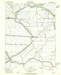 1952 Holt1953 Print · USGSThe San Joaquin Delta of the early fifties is presented here as a maze of leveed agricultural islands and vital shipping lanes. Genealogists and historians can trace the Atchison Topeka and Santa Fe rail corridor past Holt and identify family-named lands like the Drexler Tract.3 unique versions available
 - 1952 Map of Terminous, 1953 Print
 1952 Terminous1953 Print · USGSThe California Delta’s intricate water-and-tract system is captured here in the early fifties, showing a landscape shaped by reclaimed land and river transport. Researchers can trace the legacy of delta farming and infrastructure through features like Terminous, the Western Pacific line, and the Venice School.3 unique versions available
 - 1952 Map of Stockton East, 1954 Print
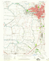
 1952 Stockton East1954 Print · USGSThe Stockton periphery was a hub of rail and air logistics in the early fifties, with military depots and municipal airfields lining the southern edge. Genealogists can locate family landmarks like Chartville Sch or trace the small settlements of Burnham and Walthal.3 unique versions available
 - 1952 Map of Stockton West, 1954 Print
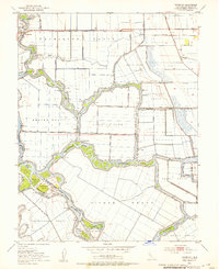
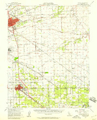
 1952 Stockton West1954 Print · USGSStockton and its vital inland port are seen here in the early fifties, showing a landscape defined by industry and its river network. Genealogists and historians can locate family plots in the Stockton Rural Cemetery or trace the early development of Fair Oaks and The Homestead.3 unique versions available
 - 1952 Map of Manteca, 1958 Print
 1952 Manteca1958 Print · USGSThe fertile San Joaquin Valley underwent significant post-war growth as irrigation and railroads connected agricultural hubs in the early fifties. Genealogists and local historians can trace rural school districts like Four Trees School and find industry landmarks such as the Sugar Refinery or the Union Memorial Cemetery.2 unique versions available
 - 1952 Map of Stockton, 1959 Print
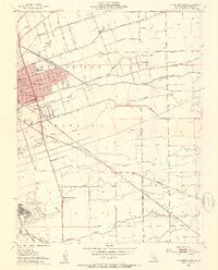
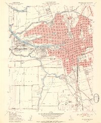
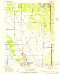
 1952 Stockton1959 Print · USGSThe San Joaquin Delta during the early fifties shows a thriving river economy and growing urban centers at the heart of the Central Valley. Genealogists can trace rural life through numerous one-room schools like David Bixler School or find industrial roots at the Sugar Refinery and Sharpe General Depot.2 unique versions available
 - 1953 Map of Lodi South, 1955 Print
 1953 Lodi South1955 Print · USGSSan Joaquin County undergoes a post-war transition in the early fifties as Stockton's northern suburbs meet Lodi's agricultural heartland. Researchers can trace the legacy of local schools like Elkhorn Sch and Live Oak School or find industrial markers like the Tom Cannery and MOKELUMNE AQUEDUCT.2 unique versions available
 - 1956 Map of San Jose
 1956 San Jose1956 Print · USGSCentral California in the mid-fifties reveals the transition from sprawling orchards to growing urban hubs like San Jose and Stockton. Genealogists and historians can trace the rail-era landscape of the Mother Lode through Chinese Camp and Tuttletown, or follow the water through the Joaquin River and Calaveras Reservoir.
 - 1956 Map of Sacramento
 1956 Sacramento1956 Print · USGSMid-century California unfolds from the delta to the high Sierra, capturing a landscape of growing valley cities and burgeoning military airbases. Genealogists and historians can trace the rail lines and river towns from Woodland to Lodi, or explore the foothill settlements of Placerville and Jackson.2 unique versions available
 - 1957 Map of Sacramento, 1966 Print
 1957 Sacramento1966 Print · USGSIn the mid-twentieth century, the California heartland was a hub of river transport, rail lines, and military airbases. Genealogists and historians can trace the development of Gold Country towns like Angels Camp and Sonora or follow the path of the Southern Pacific RR through the growing suburbs of Sacramento.4 unique versions available
End of results
Showing maps 1-10 of 10
Top cities near Stockton
- Tracy historical maps
- Manteca historical maps
- Lodi historical maps
- Lathrop historical maps
- Ripon historical maps
Top neighborhoods of Stockton
- El Pinal historical maps
- The Homestead historical maps
- Fair Oaks historical maps
- Mormon historical maps
- Ortega historical maps
- Akers historical maps
See more
Frequently asked questions
- What are the different types of historical maps available for Stockton?
- What is the oldest map of Stockton?
- Where can I purchase historical maps of Stockton for my home or office?
- Where can I download high-res historical maps of Stockton?
- Are there historical topographic maps available for Stockton?
- Is there historical aerial imagery available for Stockton?
- Where are historical maps of Stockton sourced from?