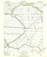
1952 Map of Holt
USGS Topo · Published 1953About this map
McDonald Tract and the surrounding reclaimed lands of the Sacramento-San Joaquin River Delta define this 1952 study. The landscape is a complex mosaic of massive agricultural tracts protected by levees and bisected by water control infrastructure, including the Mokelumne Aqueduct and the Stockton Deep Water Channel. At the heart of the region, the small settlement of Holt sits along the Atchison Topeka and Santa Fe railroad line, serving as a hub for the surrounding fertile lowlands.
Find a feature on this map
42 named features on this map. Tap any name to fly to it.
Don’t see what you’re looking for? This feature index may not catch every label — zoom into the map to look around manually.
Map Details
Editions of this 1952 Holt Map
3 editions found
Other maps of this area

1894 · Lodi
USGS Topo · 1:125,000

1910 · Castle
USGS Topo · 1:31,680

1910 · Bouldin
USGS Topo · 1:31,680

1910 · Headreach
USGS Topo · 1:31,680

1913 · Woodward Island
USGS Topo · 1:31,680

1913 · Stockton
USGS Topo · 1:31,680

1913 · Holt
USGS Topo · 1:31,680

1914 · Bethany
USGS Topo · 1:31,680

1914 · Union Island
USGS Topo · 1:31,680

1915 · Lathrop
USGS Topo · 1:31,680