1990s Maps of Santa Cruz, California
Explore 20 historic maps of Santa Cruz from the 1990s. These maps offer a rare glimpse into what life looked like during the 1990s — showing old roads, neighborhoods, homes, and landmarks that have changed or disappeared over time.
Whether you're researching your family's past, planning a metal detecting trip, or studying how Santa Cruz's landscape evolved across the 1990s, these high-resolution maps are a powerful tool for exploring the history of this region.
- Focus on a specific era: All maps on this page are from the 1990s, giving you a focused view of this time period.
- See what’s changed: Compare century-old streets, trails, and buildings to today's modern landscape using overlays and satellite layers.
- Research with precision: Use these maps for genealogy, historical research, land use analysis, or educational projects.
- View, download, or print: Maps are fully viewable online in high resolution, and can be downloaded or printed for your own records.
Start exploring Santa Cruz's history through authentic maps from the 1990s. This is your window into the past.
Santa Cruz, CA maps
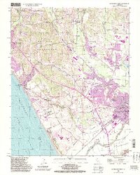
(20)- 1991 Map of Davenport, 1995 Print
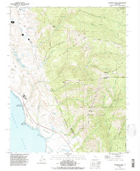
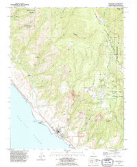 1991 Davenport1995 Print · USGSCoastal Santa Cruz County comes into focus during the early nineties, showing a landscape defined by redwood forests and industrial heritage. Trace the infrastructure of the Cement Plant at Davenport or explore the winding mountain roads near Bonny Doon and Swanton.
 - 1991 Map of Big Basin, 1995 Print
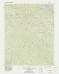
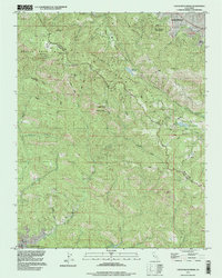
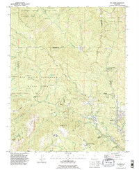 1991 Big Basin1995 Print · USGSThe Santa Cruz Mountains at the start of the nineties reveal a dense network of redwood preserves and mountain retreats. Researchers can trace historical routes like China Grade and locate secluded communities including Riverside Grove and Waterman Gap.2 unique versions available
 - 1991 Map of Ano Nuevo, 1995 Print
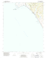 1991 Ano Nuevo1995 Print · USGSThe central California coast meets the redwood forests in the early nineties, revealing a landscape of preserves and steep canyons. Trace the rugged terrain along Last Chance Road or locate the remote Cemetery above Arroyo de las Trancas.
 - 1991 Map of Felton, 1995 Print
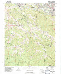
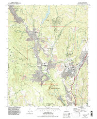 1991 Felton1995 Print · USGSThe Santa Cruz Mountains in the early nineties show a landscape defined by deep redwood canyons and growing mountain communities. Researchers can trace historic land use via the Zayante Old Railroad Grade, the Felton Covered Bridge, and the Open Pit Mine at Olympia.
 - 1991 Map of Cupertino, 1995 Print
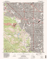 1991 Cupertino1995 Print · USGSSilicon Valley neighborhoods meet the mountain foothills in the early nineties as residential expansion fills the landscape. Researchers can locate established landmarks like the Madronia Cem, St Joseph Seminary, and the industrial Cement Plant.2 unique versions available
 - 1991 Map of Castle Rock Ridge, 1995 Print
 1991 Castle Rock Ridge1995 Print · USGSThe high ridges and deep canyons of the Santa Cruz Mountains are captured in the early nineties, tracing the wild border between Santa Clara and Santa Cruz counties. Researchers can locate named landmarks like Uncle Billys Cabin, the Lakeside Sch, and the high peak of Mount Bielawski.2 unique versions available
 - 1991 Map of Franklin Point, 1995 Print
 1991 Franklin Point1995 Print · USGSThe San Mateo coast in the early nineties displays a landscape of rugged state reserves and ancient redwood forests. Genealogists and historians can locate Pescadero High Sch, the Cemetery near Cascade Creek, and remote landmarks like Chalk Mtn.2 unique versions available
 - 1991 Map of Mindego Hill, 1995 Print
 1991 Mindego Hill1995 Print · USGSThe foothills of the Santa Cruz Mountains come alive in this early nineties survey of the San Mateo and Santa Clara borderlands. Genealogists and hikers can trace the boundaries of Portola State Park, the San Francisco Log Cabin Ranch, and family landmarks like Ewing Hill.2 unique versions available
 - 1995 Map of Watsonville West, 1998 Print
 1995 Watsonville West1998 Print · USGSThe Pajaro Valley and the Monterey Bay coastline come alive in the late twentieth century as agriculture and coastal settlements expand. Genealogists and historians can trace family-named sites like Day Valley Cem, Corralitos, and Monte Vista Christian Sch.2 unique versions available
 - 1995 Map of Watsonville East, 1998 Print
 1995 Watsonville East1998 Print · USGSCoastal agriculture and mountainous terrain meet in the Pajaro Valley during the mid-nineties. Researchers can trace the Southern Pacific rail corridor through Watsonville Junction or locate family sites at Pajaro Valley Memorial Park and Johnston Corner.2 unique versions available
 - 1996 Map of Loma Prieta, 1999 Print
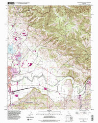
 1996 Loma Prieta1999 Print · USGSThe Santa Cruz Mountains ridge-line in the mid-nineties shows the distinct geological scarring of the San Andreas Fault Zone. Local historians can trace the old boundary of the Pueblo Lands of San Jose and the drainage of Uvas Creek near Loma Prieta.
 - 1996 Map of Mount Madonna, 2000 Print
 1996 Mount Madonna2000 Print · USGSThe foothills of the Santa Cruz Mountains and the rising suburban edge of the Santa Clara Valley are shown here in the mid-1990s. Genealogists and local historians can trace the locations of the Machado School, Mt Hope Cem, and the historic Redwood Retreat.
 - 1996 Map of Laurel, 2000 Print
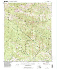
 1996 Laurel2000 Print · USGSThe Santa Cruz Mountains in the late twentieth century reveal a landscape of mountain retreats and old railroad towns. Genealogists and local historians can trace the foundations of Glenwood, the Loma Prieta Church, and the Bethany Bible College.
 - 1997 Map of Castle Rock Ridge, 1999 Print
 1997 Castle Rock Ridge1999 Print · USGSThe Santa Cruz Mountains during the late nineties reveal a landscape of high ridges and deep gulches along the Santa Clara county line. Genealogists and hikers can trace Skyline Blvd past Uncle Billys Cabin, Lakeside Sch, and the Villa Montalvo Arboretum.
 - 1997 Map of Big Basin, 1999 Print
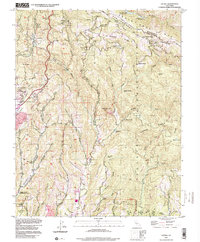
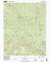 1997 Big Basin1999 Print · USGSThe Santa Cruz Mountains in the late twentieth century are defined by their deep canyons and the sprawling redwoods of the state’s oldest park. Genealogists and hikers can trace the roads to Riverside Grove, the Eagle Rock Lookout Tower, and Camp Ben Lomond.
 - 1997 Map of Davenport, 1999 Print
 1997 Davenport1999 Print · USGSThe Santa Cruz coast and redwood highlands are captured here in the late nineties, featuring the industrial hub at Davenport. Researchers can trace the inland ridge settlements of Bonny Doon and the historical site of the Big Creek Powerhouse.
 - 1997 Map of Point Ano Nuevo, 1999 Print
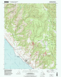
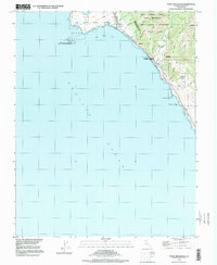 1997 Point Ano Nuevo1999 Print · USGSThe Central California coast near the San Mateo county line appears here as a preserved wilderness in the late nineties. Researchers can trace the boundaries of Año Nuevo State Reserve and locate local landmarks like Greyhound Rock or the small Cem near Scott Creek.
 - 1997 Map of Mindego Hill, 1999 Print
 1997 Mindego Hill1999 Print · USGSThe peninsula ridgeline south of Portola Valley is shown here in the late twentieth century as a landscape of protected parks and high-elevation enclaves. Researchers can trace the boundaries of Coal Mine Ridge, locate the San Francisco Log Cabin Ranch, and find family-named landmarks like Borel Hill.
 - 1998 Map of Felton, 2002 Print
 1998 Felton2002 Print · USGSThe San Lorenzo River valley in the late 1990s showcases a landscape of redwood forests and mountain settlements. Researchers can trace local history through sites like the Felton Covered Bridge, the Southern Pacific Railroad, and Mission Springs.
 - 1998 Map of Franklin Point, 2002 Print
 1998 Franklin Point2002 Print · USGSThe San Mateo and Santa Cruz coastlines meet in the 1990s at the rugged Punta del Año Nuevo headlands. Genealogists and historians can trace the remote Cemetery near Cascade Creek or locate landmarks like Chalk Mtn and the Sandy Point Guard Station.
End of results
Showing maps 1-20 of 20
Top cities of Santa Cruz
- Santa Cruz historical maps
- Watsonville historical maps
- Scotts Valley historical maps
- Capitola historical maps
- Live Oak historical maps
- Boulder Creek historical maps
Frequently asked questions
- What are the different types of historical maps available for Santa Cruz?
- What is the oldest map of Santa Cruz?
- Where can I purchase historical maps of Santa Cruz for my home or office?
- Where can I download high-res historical maps of Santa Cruz?
- Are there historical topographic maps available for Santa Cruz?
- Is there historical aerial imagery available for Santa Cruz?
- Where are historical maps of Santa Cruz sourced from?