1990s Maps of Sunbeam Woods, California
Explore 2 historic maps of Sunbeam Woods from the 1990s. These maps offer a rare glimpse into what life looked like during the 1990s — showing old roads, neighborhoods, homes, and landmarks that have changed or disappeared over time.
Whether you're researching your family's past, planning a metal detecting trip, or studying how Sunbeam Woods's landscape evolved across the 1990s, these high-resolution maps are a powerful tool for exploring the history of this region.
- Focus on a specific era: All maps on this page are from the 1990s, giving you a focused view of this time period.
- See what’s changed: Compare century-old streets, trails, and buildings to today's modern landscape using overlays and satellite layers.
- Research with precision: Use these maps for genealogy, historical research, land use analysis, or educational projects.
- View, download, or print: Maps are fully viewable online in high resolution, and can be downloaded or printed for your own records.
Start exploring Sunbeam Woods's history through authentic maps from the 1990s. This is your window into the past.
Sunbeam Woods, CA maps
(2)- 1991 Map of Big Basin, 1995 Print
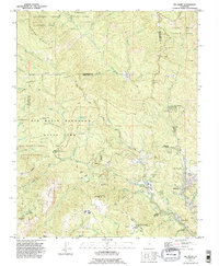 1991 Big Basin1995 Print · USGSThe Santa Cruz Mountains at the start of the nineties reveal a dense network of redwood preserves and mountain retreats. Researchers can trace historical routes like China Grade and locate secluded communities including Riverside Grove and Waterman Gap.2 unique versions available
 - 1997 Map of Big Basin, 1999 Print
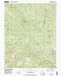 1997 Big Basin1999 Print · USGSThe Santa Cruz Mountains in the late twentieth century are defined by their deep canyons and the sprawling redwoods of the state’s oldest park. Genealogists and hikers can trace the roads to Riverside Grove, the Eagle Rock Lookout Tower, and Camp Ben Lomond.
End of results
Showing maps 1-2 of 2
Top cities near Sunbeam Woods
- San Jose historical maps
- Sunnyvale historical maps
- Santa Clara historical maps
- Mountain View historical maps
- Palo Alto historical maps
- Santa Cruz historical maps
See more
Frequently asked questions
- What are the different types of historical maps available for Sunbeam Woods?
- What is the oldest map of Sunbeam Woods?
- Where can I purchase historical maps of Sunbeam Woods for my home or office?
- Where can I download high-res historical maps of Sunbeam Woods?
- Are there historical topographic maps available for Sunbeam Woods?
- Is there historical aerial imagery available for Sunbeam Woods?
- Where are historical maps of Sunbeam Woods sourced from?