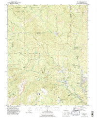
1991 Map of Big Basin
USGS Topo · Published 1995About this map
Big Basin Redwoods State Park and the complex drainage of the Santa Cruz Mountains define this landscape during the early 1990s. The map illustrates a region transitioning from isolated wilderness to a hub of conservation and recreational retreats, featuring established sites like Riverside Grove and the Boulder Creek Golf and Country Club. Deeply forested canyons are carved by Waddell Creek and the San Lorenzo River, while historical transport routes like China Grade and Empire Grade traverse the high ridges of Butano Ridge and Ben Lomond Mountain. Distinctive institutional and social markers, such as Camp Ben Lomond (California Youth Authority) and various youth camps like Camp Campbell, reveal the specialized land use within these coastal redwoods. The presence of the Eagle Rock Lookout Tower highlights the ongoing importance of fire surveillance in this densely wooded terrain.
Find a feature on this map
58 named features on this map. Tap any name to fly to it.
Don’t see what you’re looking for? This feature index may not catch every label — zoom into the map to look around manually.
Map Details
Editions of this 1991 Big Basin Map
2 editions found
Other maps of this area

1897 · Palo Alto
USGS Topo · 1:62,500

1899 · Palo Alto
USGS Topo · 1:62,500

1902 · Santa Cruz
USGS Topo · 1:125,000

1940 · Halfmoon Bay
USGS Topo · 1:62,500

1940 · Ano Nuevo
USGS Topo · 1:62,500

1941 · Ano Nuevo Pt.
USGS Topo · 1:62,500

1941 · Palo Alto
USGS Topo · 1:62,500

1942 · Ano Nuevo
USGS Topo · 1:62,500

1943 · Palo Alto
USGS Topo · 1:62,500

1943 · Halfmoon Bay
USGS Topo · 1:62,500