1940s Maps of Watsonville, California
Explore 6 historic maps of Watsonville from the 1940s. These maps offer a rare glimpse into what life looked like during the 1940s — showing old roads, neighborhoods, homes, and landmarks that have changed or disappeared over time.
Whether you're researching your family's past, planning a metal detecting trip, or studying how Watsonville's landscape evolved across the 1940s, these high-resolution maps are a powerful tool for exploring the history of this region.
- Focus on a specific era: All maps on this page are from the 1940s, giving you a focused view of this time period.
- See what’s changed: Compare century-old streets, trails, and buildings to today's modern landscape using overlays and satellite layers.
- Research with precision: Use these maps for genealogy, historical research, land use analysis, or educational projects.
- View, download, or print: Maps are fully viewable online in high resolution, and can be downloaded or printed for your own records.
Start exploring Watsonville's history through authentic maps from the 1940s. This is your window into the past.
Watsonville, CA maps
(6)- 1940 Map of San Juan Bautista
 1940 San Juan Bautista1940 Print · USGSCentral California coastal and valley life at the start of the 1940s is captured here, where four counties meet. Genealogy researchers can trace family-named sites like Patrick Breen, old rural institutions like the St Francis Orphan Asylum, and the early Sargent Oil Fields.
 - 1940 Map of Capitola
 1940 Capitola1940 Print · USGSCoastal Monterey Bay comes alive in the late 1930s, showing a landscape of rail-linked beach towns and sprawling ranchos. Genealogists and historians can trace family-named schools and early airfields like Santa Cruz Airport, Camp McQuaide, and the original rail stops of the Southern Pacific.
 - 1940 Map of Los Gatos, 1961 Print
 1940 Los Gatos1961 Print · USGSThe Santa Cruz Mountains and southern Santa Clara Valley appear in the early 1940s, showing a landscape of mountain resorts and isolated summits. Researchers can trace the footprints of Alma College, the community at Holy City, and historical landmarks like Mine Hill.2 unique versions available
 - 1943 Map of Los Gatos
 1943 Los Gatos1943 Print · USGSThe Santa Cruz Mountains and Santa Clara Valley are seen here in the early 1940s, before widespread development reshaped the landscape. Researchers can trace historic mountain communities like Holy City, old rural schools such as Hester Creek Sch, and the high-elevation Loma Prieta Lookout.
 - 1947 Map of San Jose, 1948 Print
 1947 San Jose1948 Print · USGSNorthern California's heartland is captured here just after the war, showing the rapid growth of the Santa Clara and Central Valleys. Researchers can trace the legacy of rail and water at Castle Air Force Base, Stockton, and the Hetch Hetchy Aqueduct.
 - 1948 Map of Santa Cruz
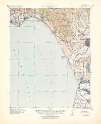
 1948 Santa Cruz1948 Print · USGSThe Central Coast and San Joaquin Valley meet in this mid-century look at the region's agricultural and military geography. Genealogists and historians can trace the paths of El Camino Real, locate family farms near Hollister, or study the footprint of the Fort Ord Military Reservation.2 unique versions available
End of results
Showing maps 1-6 of 6
Top cities near Watsonville
- San Jose historical maps
- Salinas historical maps
- Santa Cruz historical maps
- Gilroy historical maps
- Morgan Hill historical maps
- Marina historical maps
See more
Top neighborhoods of Watsonville
Frequently asked questions
- What are the different types of historical maps available for Watsonville?
- What is the oldest map of Watsonville?
- Where can I purchase historical maps of Watsonville for my home or office?
- Where can I download high-res historical maps of Watsonville?
- Are there historical topographic maps available for Watsonville?
- Is there historical aerial imagery available for Watsonville?
- Where are historical maps of Watsonville sourced from?