1950s Maps of Watsonville, California
Explore 7 historic maps of Watsonville from the 1950s. These maps offer a rare glimpse into what life looked like during the 1950s — showing old roads, neighborhoods, homes, and landmarks that have changed or disappeared over time.
Whether you're researching your family's past, planning a metal detecting trip, or studying how Watsonville's landscape evolved across the 1950s, these high-resolution maps are a powerful tool for exploring the history of this region.
- Focus on a specific era: All maps on this page are from the 1950s, giving you a focused view of this time period.
- See what’s changed: Compare century-old streets, trails, and buildings to today's modern landscape using overlays and satellite layers.
- Research with precision: Use these maps for genealogy, historical research, land use analysis, or educational projects.
- View, download, or print: Maps are fully viewable online in high resolution, and can be downloaded or printed for your own records.
Start exploring Watsonville's history through authentic maps from the 1950s. This is your window into the past.
Watsonville, CA maps
(7)- 1954 Map of Watsonville West, 1955 Print
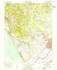 1954 Watsonville West1955 Print · USGSCoastal Santa Cruz County thrived as an agricultural and rail center in the mid-1950s, bridging the gap between the Pajaro River and the Monterey Bay bluffs. Genealogists and local historians can trace the growth of Watsonville and Freedom, locating family-named landmarks like the Monte Vista Christian Sch and the McQuiddy Sch.6 unique versions available
 - 1955 Map of Santa Cruz
 1955 Santa Cruz1955 Print · USGSCoastal Monterey Bay and the fertile Salinas Valley are captured here during the post-war expansion of the mid-fifties. Researchers can trace the era's rail-and-road network via the Southern Pacific lines and find landmarks like Fort Ord or the Lonoak School.
 - 1955 Map of Loma Prieta, 1956 Print
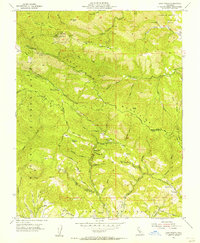 1955 Loma Prieta1956 Print · USGSThe Santa Cruz Mountains in the mid-fifties are captured here as a mix of high-altitude technology and deep canyon settlements. Researchers can find old landmarks like the Eureka Sch (Aband), the Future Farmers of America Camp, and the secluded cabins at Sveadal.6 unique versions available
 - 1955 Map of Watsonville East, 1956 Print
 1955 Watsonville East1956 Print · USGSThe fertile Pajaro Valley and southern Santa Cruz Mountains are seen here in the mid-fifties, centered on a vital agricultural and rail corridor. Genealogists and local historians can trace family sites near Johnston Corner, the Pajaro Valley Memorial Park, and the Southern Pacific hub at Watsonville Junction.6 unique versions available
 - 1956 Map of San Jose
 1956 San Jose1956 Print · USGSCentral California in the mid-fifties reveals the transition from sprawling orchards to growing urban hubs like San Jose and Stockton. Genealogists and historians can trace the rail-era landscape of the Mother Lode through Chinese Camp and Tuttletown, or follow the water through the Joaquin River and Calaveras Reservoir.
 - 1957 Map of Santa Cruz
 1957 Santa Cruz1957 Print · USGSCentral California comes into sharp focus during the late fifties, from the fog-swept Monterey Bay to the sun-drenched San Joaquin Valley. Genealogists and historians can trace the mid-century footprints of Fort Ord Military Reservation, the Southern Pacific line, and the historic streets of San Juan Bautista.
 - 1958 Map of Santa Cruz
 1958 Santa Cruz1958 Print · USGSCoastal California and the central valleys are shown during the mid-fifties, capturing a landscape of massive military reserves and vital rail arteries. Genealogists and historians can trace the Southern Pacific line through Salinas or explore the early footprints of the Fort Ord Military Reservation and San Juan Bautista.2 unique versions available
End of results
Showing maps 1-7 of 7
Top cities near Watsonville
- San Jose historical maps
- Salinas historical maps
- Santa Cruz historical maps
- Gilroy historical maps
- Morgan Hill historical maps
- Marina historical maps
See more
Top neighborhoods of Watsonville
Frequently asked questions
- What are the different types of historical maps available for Watsonville?
- What is the oldest map of Watsonville?
- Where can I purchase historical maps of Watsonville for my home or office?
- Where can I download high-res historical maps of Watsonville?
- Are there historical topographic maps available for Watsonville?
- Is there historical aerial imagery available for Watsonville?
- Where are historical maps of Watsonville sourced from?