1980s Maps of Loyalton, California
Explore 2 historic maps of Loyalton from the 1980s. These maps offer a rare glimpse into what life looked like during the 1980s — showing old roads, neighborhoods, homes, and landmarks that have changed or disappeared over time.
Whether you're researching your family's past, planning a metal detecting trip, or studying how Loyalton's landscape evolved across the 1980s, these high-resolution maps are a powerful tool for exploring the history of this region.
- Focus on a specific era: All maps on this page are from the 1980s, giving you a focused view of this time period.
- See what’s changed: Compare century-old streets, trails, and buildings to today's modern landscape using overlays and satellite layers.
- Research with precision: Use these maps for genealogy, historical research, land use analysis, or educational projects.
- View, download, or print: Maps are fully viewable online in high resolution, and can be downloaded or printed for your own records.
Start exploring Loyalton's history through authentic maps from the 1980s. This is your window into the past.
Loyalton, CA maps
(2)- 1981 Map of Antelope Valley, 1982 Print
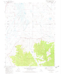 1981 Antelope Valley1982 Print · USGSThe high basins of the Sierras are captured here in the early eighties at the intersection of Plumas and Sierra Counties. Local historians can trace water management systems including the Eastside Canal, the Western Pacific line, and family-named points like Lombardi Point.3 unique versions available
 - 1981 Map of Loyalton, 1982 Print
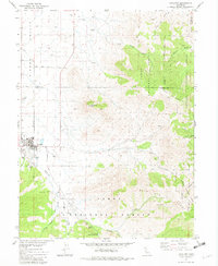 1981 Loyalton1982 Print · USGSLoyalton and the surrounding Sierra Valley are captured here in the early eighties as a hub of ranching and forestry. Genealogists and researchers can locate the local Cemetery and Hospital, or trace the rugged geography of Mount Ina Coolbrith and Smithneck Creek.
End of results
Showing maps 1-2 of 2
Top cities near Loyalton
Frequently asked questions
- What are the different types of historical maps available for Loyalton?
- What is the oldest map of Loyalton?
- Where can I purchase historical maps of Loyalton for my home or office?
- Where can I download high-res historical maps of Loyalton?
- Are there historical topographic maps available for Loyalton?
- Is there historical aerial imagery available for Loyalton?
- Where are historical maps of Loyalton sourced from?