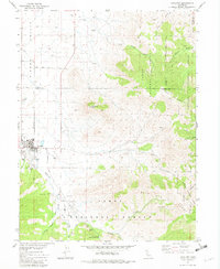
1981 Map of Loyalton
USGS Topo · Published 1982About this map
Loyalton sits at the southern edge of the expansive Sierra Valley, serving as a focal point for this 1980s landscape where ranching and forestry intersect. The town site includes local infrastructure such as a Hospital and a Cemetery, while the surrounding mountains are managed as part of the Tahoe National Forest and Toiyabe National Forest. The map captures a transition from the level valley floor, marked by Dotta Lane and Pacific Western Road, to the steep drainages of Smithneck Creek and Bear Valley Creek. Notable geographic landmarks like Mount Ina Coolbrith and Elephants Head rise above the canyons, while the Alvin A. Powers Memorial Picnic Grove indicates recreational use of the public lands. Extensive extractive activity is evidenced by numerous Borrow Pits and a Gravel Pit near the settlement, highlighting the region's industrial connection to its natural resources.
Find a feature on this map
31 named features on this map. Tap any name to fly to it.
Don’t see what you’re looking for? This feature index may not catch every label — zoom into the map to look around manually.
Map Details
Editions of this 1981 Loyalton Map
This is the sole edition of this map. No revisions or reprints were ever made.
Other maps of this area

1890 · Sierraville
USGS Topo · 1:125,000

1892 · Sierraville
USGS Topo · 1:125,000

1894 · Sierraville
USGS Topo · 1:125,000

1950 · Chilcoot
USGS Topo · 1:62,500

1950 · Portola
USGS Topo · 1:62,500

1955 · Loyalton
USGS Topo · 1:62,500

1955 · Sierraville
USGS Topo · 1:62,500

1958 · Chico
USGS Topo · 1:250,000

1960 · Chico
USGS Topo · 1:250,000
1972 · Reconnaissance Peak
USGS Topo · 1:24,000