1940s Maps of Larkfield-Wikiup, California
Explore 7 historic maps of Larkfield-Wikiup from the 1940s. These maps offer a rare glimpse into what life looked like during the 1940s — showing old roads, neighborhoods, homes, and landmarks that have changed or disappeared over time.
Whether you're researching your family's past, planning a metal detecting trip, or studying how Larkfield-Wikiup's landscape evolved across the 1940s, these high-resolution maps are a powerful tool for exploring the history of this region.
- Focus on a specific era: All maps on this page are from the 1940s, giving you a focused view of this time period.
- See what’s changed: Compare century-old streets, trails, and buildings to today's modern landscape using overlays and satellite layers.
- Research with precision: Use these maps for genealogy, historical research, land use analysis, or educational projects.
- View, download, or print: Maps are fully viewable online in high resolution, and can be downloaded or printed for your own records.
Start exploring Larkfield-Wikiup's history through authentic maps from the 1940s. This is your window into the past.
Larkfield-Wikiup, CA maps
(7)- 1940 Map of Healdsburg
 1940 Healdsburg1940 Print · USGSSonoma County's wine and timber country is captured here just before the mid-century, following the winding Russian River through thriving valley towns. Genealogists can locate family-named landmarks and rural schoolhouses like Guilford Sch, Lytton Sch, and the Oak Mound Cem.3 unique versions available
 - 1942 Map of Sebastopol
 1942 Sebastopol1942 Print · USGSWestern Sonoma County comes into focus in the early 1940s, showing a landscape defined by apple orchards and redwood groves. Genealogists can trace family footprints through rural sites like Gold Ridge Sch, the Northwestern Pacific RR line, and Bohemian Grove.3 unique versions available
 - 1943 Map of Calistoga, 1955 Print
 1943 Calistoga1955 Print · USGSUpper Napa Valley and the rugged Lake County border are captured here during the 1940s, a period defined by mercury mining and early tourism. Researchers can trace family-named landmarks and industrial sites like the Oat Hill Mine, Mark West Springs, and the Petrified Forest.
 - 1944 Map of Santa Rosa
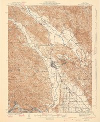
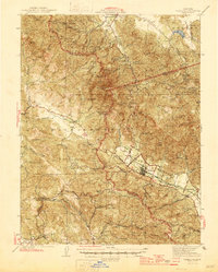
 1944 Santa Rosa1944 Print · USGSSonoma County transitions from its early land-grant heritage to a mid-century agricultural hub in the years following the 1942 revision. Genealogists and researchers can locate numerous country schools and family-linked landmarks like Sonoma State Home, Adobe Fort, and Grange Hall.2 unique versions available
 - 1945 Map of Calistoga
 1945 Calistoga1945 Print · USGSCalistoga and the surrounding tri-county ridges are documented here during the mid-forties, capturing a landscape defined by mercury and silver mining. Researchers can trace the Southern Pacific RR and locate rural landmarks like the Silverado Mine or Mark West Springs.2 unique versions available
 - 1947 Map of Santa Rosa
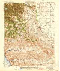
 1947 Santa Rosa1947 Print · USGSNorthern California in the late 1940s was a landscape of agricultural valleys and vital rail hubs. Trace the historic routes of the Northwestern Pacific through Healdsburg or explore the mid-century waterfronts of Vallejo and Benicia near Mare Island.
 - 1949 Map of Santa Rosa
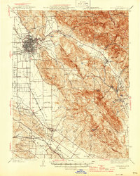
 1949 Santa Rosa1949 Print · USGSThe North Bay and Wine Country appear here in the late 1940s, when the Northwestern Pacific RR still dominated regional transit. Genealogists and historians can trace old coastal outposts like Anchor Bay Settlement and the early layout of Santa Rosa.2 unique versions available
End of results
Showing maps 1-7 of 7
Top cities near Larkfield-Wikiup
- Santa Rosa historical maps
- Petaluma historical maps
- Rohnert Park historical maps
- Windsor historical maps
- Healdsburg historical maps
- Sebastopol historical maps
See more
Frequently asked questions
- What are the different types of historical maps available for Larkfield-Wikiup?
- What is the oldest map of Larkfield-Wikiup?
- Where can I purchase historical maps of Larkfield-Wikiup for my home or office?
- Where can I download high-res historical maps of Larkfield-Wikiup?
- Are there historical topographic maps available for Larkfield-Wikiup?
- Is there historical aerial imagery available for Larkfield-Wikiup?
- Where are historical maps of Larkfield-Wikiup sourced from?