1900s (20th Century) Maps of Larkfield-Wikiup, California
Explore 29 historic maps of Larkfield-Wikiup from the 1900s (20th Century). These maps offer a rare glimpse into what life looked like during the 1900s — showing old roads, neighborhoods, homes, and landmarks that have changed or disappeared over time.
Whether you're researching your family's past, planning a metal detecting trip, or studying how Larkfield-Wikiup's landscape evolved across the 1900s, these high-resolution maps are a powerful tool for exploring the history of this region.
- Focus on a specific era: All maps on this page are from the 1900s, giving you a focused view of this time period.
- See what’s changed: Compare century-old streets, trails, and buildings to today's modern landscape using overlays and satellite layers.
- Research with precision: Use these maps for genealogy, historical research, land use analysis, or educational projects.
- View, download, or print: Maps are fully viewable online in high resolution, and can be downloaded or printed for your own records.
Start exploring Larkfield-Wikiup's history through authentic maps from the 1900s. This is your window into the past.
Larkfield-Wikiup, CA maps
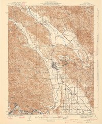
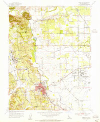
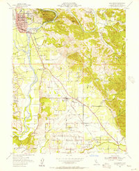
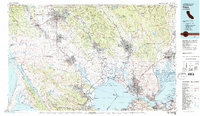
(29)- 1916 Map of Santa Rosa
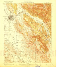 1916 Santa Rosa1916 Print · USGSSonoma County in the mid-1910s is a landscape of established rail towns and historic land grants. Researchers can trace early infrastructure through sites like the Sonoma State Home, Adobe Fort, and rural landmarks such as Grangers Hall or the Winery.3 unique versions available
 - 1920 Map of Healdsburg
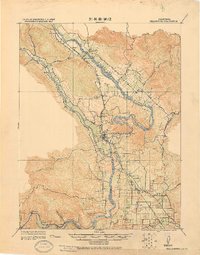 1920 Healdsburg1920 Print · USGSThe Russian River valley in the early twentieth century was a landscape of expanding viticulture and rail transit. Genealogists and historians can trace the old depots and homesteads from Geyserville to Windsor, finding specific landmarks like the Orphans Home and Olive Hill Cem.
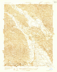
 - 1927 Map of Calistoga
 1927 Calistoga1927 Print · USGSUpper Napa Valley and the surrounding peaks come alive in this 1920s tactical survey. Genealogists and researchers can trace the early mercury industry at the Oat Hill Mine, locate family roots near Langstry Ranch, or follow the old Southern Pacific line through Larkmead and Bale.2 unique versions available
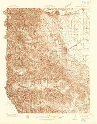
 - 1933 Map of Healdsburg
 1933 Healdsburg1933 Print · USGSSonoma County's wine and river country comes alive in the early 1930s, showing the early footprints of HEALDSBURG and Geyserville. Researchers can trace the Northwestern Pacific rail line to vanished sidings and schools like Grape Sch and Sotoyome Sch.
 - 1935 Map of Sebastopol
 1935 Sebastopol1935 Print · USGSThe Sonoma County hills and the Gold Ridge fruit district are captured here in the mid-1930s, just as the regional rail network still connected small agricultural hamlets. Genealogists can trace family footprints at Watson Sch, Two Rock Ch, and the rural community of Bloomfield.
 - 1940 Map of Healdsburg
 1940 Healdsburg1940 Print · USGSSonoma County's wine and timber country is captured here just before the mid-century, following the winding Russian River through thriving valley towns. Genealogists can locate family-named landmarks and rural schoolhouses like Guilford Sch, Lytton Sch, and the Oak Mound Cem.3 unique versions available
 - 1942 Map of Sebastopol
 1942 Sebastopol1942 Print · USGSWestern Sonoma County comes into focus in the early 1940s, showing a landscape defined by apple orchards and redwood groves. Genealogists can trace family footprints through rural sites like Gold Ridge Sch, the Northwestern Pacific RR line, and Bohemian Grove.3 unique versions available
 - 1943 Map of Calistoga, 1955 Print
 1943 Calistoga1955 Print · USGSUpper Napa Valley and the rugged Lake County border are captured here during the 1940s, a period defined by mercury mining and early tourism. Researchers can trace family-named landmarks and industrial sites like the Oat Hill Mine, Mark West Springs, and the Petrified Forest.
 - 1944 Map of Santa Rosa
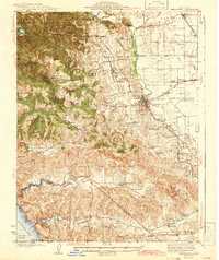
 1944 Santa Rosa1944 Print · USGSSonoma County transitions from its early land-grant heritage to a mid-century agricultural hub in the years following the 1942 revision. Genealogists and researchers can locate numerous country schools and family-linked landmarks like Sonoma State Home, Adobe Fort, and Grange Hall.2 unique versions available
 - 1945 Map of Calistoga
 1945 Calistoga1945 Print · USGSCalistoga and the surrounding tri-county ridges are documented here during the mid-forties, capturing a landscape defined by mercury and silver mining. Researchers can trace the Southern Pacific RR and locate rural landmarks like the Silverado Mine or Mark West Springs.2 unique versions available
 - 1947 Map of Santa Rosa
 1947 Santa Rosa1947 Print · USGSNorthern California in the late 1940s was a landscape of agricultural valleys and vital rail hubs. Trace the historic routes of the Northwestern Pacific through Healdsburg or explore the mid-century waterfronts of Vallejo and Benicia near Mare Island.
 - 1949 Map of Santa Rosa
 1949 Santa Rosa1949 Print · USGSThe North Bay and Wine Country appear here in the late 1940s, when the Northwestern Pacific RR still dominated regional transit. Genealogists and historians can trace old coastal outposts like Anchor Bay Settlement and the early layout of Santa Rosa.2 unique versions available
 - 1954 Map of Sebastopol, 1955 Print
 1954 Sebastopol1955 Print · USGSMid-century Sonoma County comes alive here, showcasing the rail-and-orchard landscape around Sebastopol and the Laguna de Santa Rosa wetlands. Genealogists can trace early landmarks like Sousas Corner, Graton, and numerous rural schools from Vine Hill Sch to Piner Sch.6 unique versions available
 - 1954 Map of Santa Rosa, 1955 Print
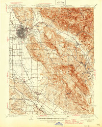
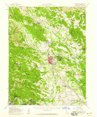
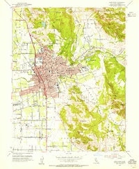 1954 Santa Rosa1955 Print · USGSSanta Rosa in the mid-fifties is a thriving hub of civic life and new suburban development set against the backdrop of Sonoma County’s mountains. Researchers can trace the legacy of local landmarks like the Luther Burbank Gardens, the Rural Cemetery, and the Bennett Valley Grange Hall.6 unique versions available
 - 1954 Map of Sebastopol, 1959 Print
 1954 Sebastopol1959 Print · USGSSonoma County's mid-century orchard lands and redwood groves are captured here just as the post-war era reshaped the region's rural character. Researchers can trace family homesteads near dozens of country schools like Vine Hill School or locate operations at the Naval Auxiliary Air Station and Two Rock Ranch Sta Military Res.
 - 1954 Map of Santa Rosa, 1959 Print
 1954 Santa Rosa1959 Print · USGSSonoma County at the mid-century shows a landscape of expanding valley towns and military infrastructure. Researchers can locate the Cotati Naval Auxiliary Air Station or trace the Jack London Ranch and Penngrove rail stops.2 unique versions available
 - 1955 Map of Healdsburg, 1956 Print
 1955 Healdsburg1956 Print · USGSMid-century Sonoma County comes alive along the Russian River in this detailed survey of the valley floor and its surrounding peaks. Genealogists and local historians can locate rural landmarks like Shiloh Cem, the Grange Hall near Windsor, and the Northwestern Pacific rail line.3 unique versions available
 - 1955 Map of Healdsburg, 1959 Print
 1955 Healdsburg1959 Print · USGSIn the mid-1950s, the Russian River valley supported a flourishing network of orchards, ranches, and small rail stops before the onset of modern development. Genealogists and local historians can trace rural roots at Shiloh Church, Beeson Cemetery, and vanished school sites like Felta Sch.2 unique versions available
 - 1958 Map of Mark West Springs, 1961 Print
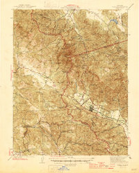
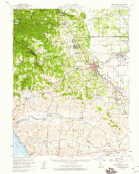
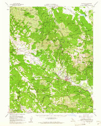
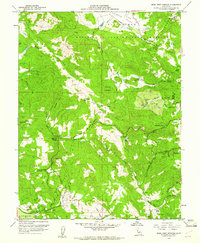 1958 Mark West Springs1961 Print · USGSSonoma County hills come alive in this mid-century survey of the rugged territory between Fulton and the Napa border. Genealogists and local historians can trace family-named routes and early sites like the Petrified Forest, the Mark West Creek Rancheria, and Alpine School.3 unique versions available
 - 1958 Map of Santa Rosa, 1968 Print
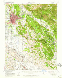
 1958 Santa Rosa1968 Print · USGSThe North Bay and Wine Country are captured in the mid-twentieth century as the region balanced its agricultural roots with a growing military and recreational footprint. Researchers can trace the Northwestern Pacific RR through the Russian River valley or locate landmarks like the Petaluma Adobe Historical Monument and The Geysers Resort.3 unique versions available
 - 1959 Map of Calistoga, 1962 Print
 1959 Calistoga1962 Print · USGSThe northern Napa Valley and Mayacamas highlands are captured here in the late fifties during a period of rising viticulture and active mining. Researchers can locate historic sites like the Bale Mill Historical Monument or trace dozens of old mercury workings such as the Oat Hill Extension Mine and Mirabel Mine.2 unique versions available
 - 1962 Map of Santa Rosa
 1962 Santa Rosa1962 Print · USGSThe North Bay and Wine Country were entering a period of significant growth in the early sixties, anchored by established rail corridors and coastal maritime commerce. Genealogists and historians can trace the development of Santa Rosa, locate the Mare Island Naval Shipyard, and follow the Northwestern Pacific RR through the Cotati Valley.
 - 1964 Map of Santa Rosa
 1964 Santa Rosa1964 Print · USGSThe North Bay and Wine Country appear in the mid-fifties during a period of significant military and educational growth. Trace old rail lines like the Northwestern Pacific RR and explore historic sites from Petaluma to the Benicia Arsenal.
 - 1972 Map of Healdsburg, 1975 Print
 1972 Healdsburg1975 Print · USGSNorthern California wine country and the lower Lake County basins appear here during the early seventies. Trace the Northwestern Pacific rail line and discover foothill communities like Middletown and Loch Lomond.2 unique versions available
 - 1983 Map of Napa
 1983 Napa1983 Print · USGSThe North Bay and wine country are captured in the early eighties as suburban growth began to surround traditional agricultural centers. Researchers can trace the rail corridors of the Northwestern Pacific Railroad, the grounds of Mare Island Naval Shipyard, and the reach of the San Andreas Rift Zone.
Showing maps 1-25 of 29
Top cities near Larkfield-Wikiup
- Santa Rosa historical maps
- Petaluma historical maps
- Rohnert Park historical maps
- Windsor historical maps
- Healdsburg historical maps
- Sebastopol historical maps
See more
Frequently asked questions
- What are the different types of historical maps available for Larkfield-Wikiup?
- What is the oldest map of Larkfield-Wikiup?
- Where can I purchase historical maps of Larkfield-Wikiup for my home or office?
- Where can I download high-res historical maps of Larkfield-Wikiup?
- Are there historical topographic maps available for Larkfield-Wikiup?
- Is there historical aerial imagery available for Larkfield-Wikiup?
- Where are historical maps of Larkfield-Wikiup sourced from?