1990s Maps of Larkfield-Wikiup, California
Explore 4 historic maps of Larkfield-Wikiup from the 1990s. These maps offer a rare glimpse into what life looked like during the 1990s — showing old roads, neighborhoods, homes, and landmarks that have changed or disappeared over time.
Whether you're researching your family's past, planning a metal detecting trip, or studying how Larkfield-Wikiup's landscape evolved across the 1990s, these high-resolution maps are a powerful tool for exploring the history of this region.
- Focus on a specific era: All maps on this page are from the 1990s, giving you a focused view of this time period.
- See what’s changed: Compare century-old streets, trails, and buildings to today's modern landscape using overlays and satellite layers.
- Research with precision: Use these maps for genealogy, historical research, land use analysis, or educational projects.
- View, download, or print: Maps are fully viewable online in high resolution, and can be downloaded or printed for your own records.
Start exploring Larkfield-Wikiup's history through authentic maps from the 1990s. This is your window into the past.
Larkfield-Wikiup, CA maps
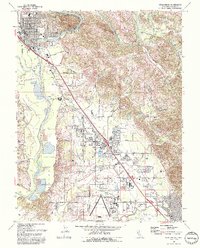
(4)- 1993 Map of Mark West Springs
 1993 Mark West Springs1993 Print · USGSSonoma County's volcanic ridges and historic land grants are captured here in the early nineties. Researchers can trace the winding Petrified Forest Road to find the Petrified Forest, the Franz Valley School, and old landmarks like Mark West Springs.2 unique versions available
 - 1993 Map of Healdsburg
 1993 Healdsburg1993 Print · USGSSonoma County's wine country is captured in the early nineties as Healdsburg and Windsor expanded along the Russian River. Genealogists and researchers can trace the Northwestern Pacific rail line and locate the historic Shiloh Cem or the local Grange Hall.2 unique versions available
 - 1994 Map of Santa Rosa, 1999 Print
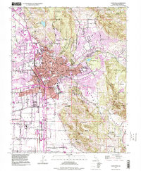 1994 Santa Rosa1999 Print · USGSSanta Rosa and its surrounding valleys are captured in the late nineties during a period of steady growth. Researchers can trace the legacy of regional landmarks like the Rural Cemetery, the Sonoma County Fairgrounds, and the Luther Burbank Gardens.
 - 1998 Map of Mark West Springs, 2002 Print
 1998 Mark West Springs2002 Print · USGSThe Mayacamas Mountains in the late 1990s reveal a landscape of creek-carved valleys and rural landmarks between Santa Rosa and Calistoga. Researchers can trace local history through the Petrified Forest, find the Grave on the eastern hills, or follow Franz Valley School Road.
End of results
Showing maps 1-4 of 4
Top cities near Larkfield-Wikiup
- Santa Rosa historical maps
- Petaluma historical maps
- Rohnert Park historical maps
- Windsor historical maps
- Healdsburg historical maps
- Sebastopol historical maps
See more
Frequently asked questions
- What are the different types of historical maps available for Larkfield-Wikiup?
- What is the oldest map of Larkfield-Wikiup?
- Where can I purchase historical maps of Larkfield-Wikiup for my home or office?
- Where can I download high-res historical maps of Larkfield-Wikiup?
- Are there historical topographic maps available for Larkfield-Wikiup?
- Is there historical aerial imagery available for Larkfield-Wikiup?
- Where are historical maps of Larkfield-Wikiup sourced from?