1900s (20th Century) Maps of Yuba City, California
Explore 12 historic maps of Yuba City from the 1900s (20th Century). These maps offer a rare glimpse into what life looked like during the 1900s — showing old roads, neighborhoods, homes, and landmarks that have changed or disappeared over time.
Whether you're researching your family's past, planning a metal detecting trip, or studying how Yuba City's landscape evolved across the 1900s, these high-resolution maps are a powerful tool for exploring the history of this region.
- Focus on a specific era: All maps on this page are from the 1900s, giving you a focused view of this time period.
- See what’s changed: Compare century-old streets, trails, and buildings to today's modern landscape using overlays and satellite layers.
- Research with precision: Use these maps for genealogy, historical research, land use analysis, or educational projects.
- View, download, or print: Maps are fully viewable online in high resolution, and can be downloaded or printed for your own records.
Start exploring Yuba City's history through authentic maps from the 1900s. This is your window into the past.
Yuba City, CA maps
(12)- 1911 Map of Sutter
 1911 Sutter1911 Print · USGSAgricultural life in the Sacramento Valley thrived during the early 1900s, anchored by the iconic Marysville Buttes. Genealogists and historians can trace the local school districts of Liveoak School and Washington School or locate rail stops at Nuestro and Encinal.
 - 1911 Map of Yuba City
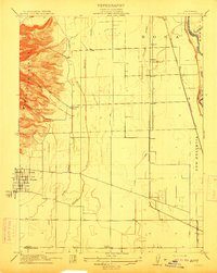
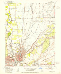
 1911 Yuba City1911 Print · USGSThe confluence of the Feather and Yuba Rivers comes to life in the early twentieth century, showing a region deeply tied to its rail and water networks. Genealogists and historians can trace the exact 1909 footprints of Marysville, Woodruff School, and the Southern Pacific RR.2 unique versions available
 - 1911 Map of Gilsizer Slough
 1911 Gilsizer Slough1911 Print · USGSSutter County's agricultural heartland is documented here in the years before heavy industrialization, showing the natural meanders of the Snake River. Family historians can pinpoint early landmarks like Lincoln School and O'Bannon School along the winding Gilsizer Slough.
 - 1911 Map of Ostrom
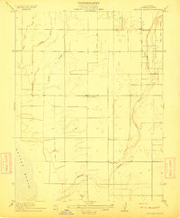
 1911 Ostrom1911 Print · USGSThe Yuba County lowlands were a hub of competing rail lines and river transport in the years before the Great War. Genealogists can trace family footprints near Ella School, the stop at Alicia, or the historic wetlands of Plumas Lake.
 - 1952 Map of Gilsizer Slough, 1953 Print
 1952 Gilsizer Slough1953 Print · USGSSutter County's agricultural heartland is captured here in the early fifties, showing a landscape defined by drainage canals and orchard grids. Researchers can locate vanished rural landmarks like Lincoln Sch, Oswald, and the KUBA Radio Towers among the many family-named roads.3 unique versions available
 - 1952 Map of Olivehurst, 1953 Print
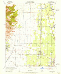
 1952 Olivehurst1953 Print · USGSThe Yuba and Feather River floodplains in the early fifties show a fascinating mix of orchard land, rail corridors, and new suburban growth. Genealogists can locate family landmarks like Boardman Ranch or trace the early foundations of Ella Sch and Olivehurst School.5 unique versions available
 - 1952 Map of Yuba City, 1954 Print
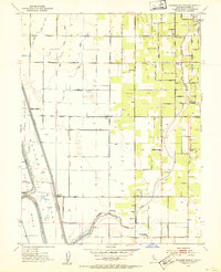
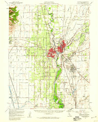
 1952 Yuba City1954 Print · USGSMarysville and Yuba City are captured at their mid-century confluence during an era of significant expansion and industrial activity. Genealogists can locate family landmarks like Marysville Cemetery, while historians can trace the SOUTHERN PACIFIC rails and the Dantoni agricultural colony.5 unique versions available
 - 1952 Map of Sutter, 1955 Print
 1952 Sutter1955 Print · USGSThe Sacramento Valley's agricultural heartland is captured here in the early fifties, where the volcanic Sutter Buttes meet a network of canals and rail lines. Researchers can locate family landmarks such as Franklin Home Site Church, the rural Encinal Sch, and the busy Packing Plant near the Feather River.4 unique versions available
 - 1952 Map of Marysville, 1959 Print
 1952 Marysville1959 Print · USGSThe Yuba-Sutter region at mid-century reveals a landscape of river-driven agriculture and expanding rail hubs. Researchers can trace the development of Yuba City and Marysville alongside rural landmarks like Plumas Lake and the Sutter Nat Wildlife Refuge.3 unique versions available
 - 1958 Map of Chico, 1962 Print
 1958 Chico1962 Print · USGSMid-century Northern California comes to life across the Central Valley and high Sierras as the postwar economy transformed the landscape. Trace the rail lines of the Southern Pacific RR, locate family roots near Chico Cem, or explore the early layout of Paradise and Beale Air Force Base.4 unique versions available
 - 1960 Map of Chico
 1960 Chico1960 Print · USGSThe Northern California high country and Sacramento Valley meet in this 1960s-era landscape of mining towns and river settlements. Trace the rail-and-water economy of the gold country through the Empire Mine, Beale Air Force Base, and the Western Pacific Railroad.
 - 1993 Map of Yuba City, 1994 Print
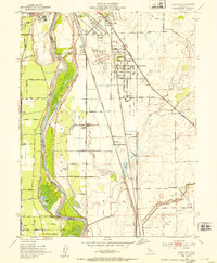
 1993 Yuba City1994 Print · USGSThe Sacramento Valley and Sierra Nevada foothills meet in the 1990s, where agricultural bypasses and river networks surround the iconic Sutter Buttes. Researchers can trace the rail corridors of the Southern Pacific and Western Pacific through hubs like Marysville and Gridley.
End of results
Showing maps 1-12 of 12
Top cities near Yuba City
- Linda historical maps
- Olivehurst historical maps
- Marysville historical maps
- Live Oak historical maps
- Gridley historical maps
- Plumas Lake historical maps
See more
Frequently asked questions
- What are the different types of historical maps available for Yuba City?
- What is the oldest map of Yuba City?
- Where can I purchase historical maps of Yuba City for my home or office?
- Where can I download high-res historical maps of Yuba City?
- Are there historical topographic maps available for Yuba City?
- Is there historical aerial imagery available for Yuba City?
- Where are historical maps of Yuba City sourced from?