1950s Maps of Tulare, California
Explore 9 historic maps of Tulare from the 1950s. These maps offer a rare glimpse into what life looked like during the 1950s — showing old roads, neighborhoods, homes, and landmarks that have changed or disappeared over time.
Whether you're researching your family's past, planning a metal detecting trip, or studying how Tulare's landscape evolved across the 1950s, these high-resolution maps are a powerful tool for exploring the history of this region.
- Focus on a specific era: All maps on this page are from the 1950s, giving you a focused view of this time period.
- See what’s changed: Compare century-old streets, trails, and buildings to today's modern landscape using overlays and satellite layers.
- Research with precision: Use these maps for genealogy, historical research, land use analysis, or educational projects.
- View, download, or print: Maps are fully viewable online in high resolution, and can be downloaded or printed for your own records.
Start exploring Tulare's history through authentic maps from the 1950s. This is your window into the past.
Tulare, CA maps
(9)- 1950 Map of Paige, 1958 Print
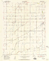 1950 Paige1958 Print · USGSThe Tulare County countryside comes into focus at mid-century, showing an agricultural landscape deeply shaped by irrigation and rail. Genealogists and researchers can trace rural school locations like Buena Vista Sch, the grounds of Colpien Ranch, and the path of the Santa Fe railroad.2 unique versions available
 - 1950 Map of Tulare, 1971 Print
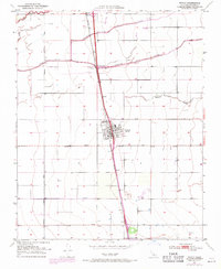
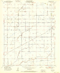
 1950 Tulare1971 Print · USGSTulare's mid-century landscape is defined by its role as a San Joaquin Valley rail and irrigation hub. Researchers can trace the development of the County Fairgrounds and Oakland Colony, or locate landmarks like Tulare Cemetery and Rankin Airfield.2 unique versions available
 - 1950 Map of Tipton, 1971 Print
 1950 Tipton1971 Print · USGSTipton and the surrounding Central Valley ranch lands are shown at mid-century as the railroad and river systems defined local life. Genealogists and historians can locate the Tipton Cem, the southern siding at Quail, and the course of the Tule River.2 unique versions available
 - 1951 Map of Tipton
 1951 Tipton1951 Print · USGSCentral Valley agriculture and the rail economy define this part of Tulare County at mid-century. Genealogists can locate family holdings near Tipton and Quail, or trace the winding courses of Mitchell Slough and the Tule River.
 - 1951 Map of Tulare
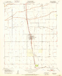
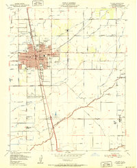 1951 Tulare1951 Print · USGSMid-century Tulare was a bustling agricultural and rail center at the intersection of two major western railroads. Genealogists and historians can trace the foundations of the community through the Tulare Cemetery, St Aloysius Sch, and the Old Peoples Home.2 unique versions available
 - 1951 Map of Paige
 1951 Paige1951 Print · USGSTulare County's agricultural heartland is documented here in the early 1950s as a sophisticated network of canals and rails. Genealogists and historians can trace family properties near rural schools like Buena Vista Sch or follow the Atchison Topeka and Santa Fe tracks through Paige.
 - 1955 Map of Fresno
 1955 Fresno1955 Print · USGSThe Central Valley and High Sierra meet in this mid-fifties study of California’s agricultural and wilderness heart. Researchers can trace the rail-side growth of Sanger, Selma, and Reedley or locate high-altitude landmarks like Mt Whitney and Hume Lake.
 - 1956 Map of Fresno
 1956 Fresno1956 Print · USGSThe Central Valley and High Sierra meet in this mid-fifties survey of a rapidly developing California interior. Researchers can trace the rail-and-water networks of Visalia, the footprint of Tulare Lake, and the remote heights of Sequoia National Park.
 - 1958 Map of Fresno
 1958 Fresno1958 Print · USGSThe Central Valley and High Sierra meet in this mid-century survey of the California heartland. Researchers can trace the rail-and-road network connecting Fresno and Visalia or locate high-country landmarks like Mt Whitney and Sequoia National Park.
End of results
Showing maps 1-9 of 9
Top cities near Tulare
- Visalia historical maps
- Corcoran historical maps
- Exeter historical maps
- Farmersville historical maps
- Woodlake historical maps
- Ivanhoe historical maps
See more
Frequently asked questions
- What are the different types of historical maps available for Tulare?
- What is the oldest map of Tulare?
- Where can I purchase historical maps of Tulare for my home or office?
- Where can I download high-res historical maps of Tulare?
- Are there historical topographic maps available for Tulare?
- Is there historical aerial imagery available for Tulare?
- Where are historical maps of Tulare sourced from?