Old Maps of Moorpark, California for Genealogy
Trace your family roots with 20 historic maps of Moorpark. These high-res maps reveal old neighborhoods, homesites, landmarks, and streets — helping you uncover where your ancestors lived and how the area evolved over time.
- Explore historic neighborhoods: Identify where your relatives may have lived in the 1800s or 1900s.
- Compare maps over time: Trace the changes in streets, buildings, and landmarks for multi-generational research.
- Perfect for genealogy & ancestry research: Used by family historians and researchers to map out lineage and migration.
These maps are an incredible resource for exploring your personal connection to Moorpark's past.
Moorpark, CA maps
(20)- 1900 Map of Piru
 1900 Piru1900 Print · USGSVentura County thrived along the rail-and-river corridor at the turn of the century as agriculture and ranching expanded. Trace the early layouts of Fillmore, Moorpark, and Piru or locate family landmarks in Bardsdale and Camulos.
 - 1903 Map of Camulos
 1903 Camulos1903 Print · USGSSouthern California at the dawn of the twentieth century shows a landscape of ranchos and early rail towns. Trace the old routes through Simi and Camulos, or locate vanished stops like Ternez Siding and the coastal piers at Port Los Angeles.5 unique versions available
 - 1921 Map of Piru
 1921 Piru1921 Print · USGSThe Santa Clara River valley and southern Ventura County are shown here in the early twentieth century as the rail network expanded. Genealogists and historians can trace old property lines and rail stops at Sespe Sta, Camulos, and Bardsdale.4 unique versions available
 - 1941 Map of Piru, 1963 Print
 1941 Piru1963 Print · USGSVentura County ranching and rail life are captured here during the early 1940s as citrus and oil industries shaped the valley. Researchers can trace historic family holdings like the Frey Ranch and locate vanished local landmarks such as San Cayetano Sch or the Temescal Guard Station.
 - 1949 Map of Los Angeles
 1949 Los Angeles1949 Print · USGSSouthern California and the South Coast appear at the onset of the post-war boom, from the Channel Islands to the Mojave Desert. Trace early aviation sites like Lockheed Air Terminal and mining history at the Redrock Quicksilver Mine and Redrover Mine.2 unique versions available
 - 1951 Map of Simi, 1952 Print
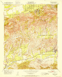
 1951 Simi1952 Print · USGSSimi Valley and Moorpark are captured in the early fifties during an era of agricultural prosperity and early suburban planning. Genealogists and local historians can locate the Virginia Colony settlement, the Simi Sta railroad stop, and the Cem south of the tracks.6 unique versions available
 - 1951 Map of Moorpark, 1952 Print
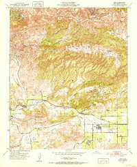
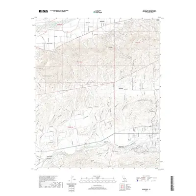
 1951 Moorpark1952 Print · USGSVentura County citrus groves and oil fields define this landscape in the early fifties. Genealogists and historians can trace the foundations of Moorpark, locate the Bardsdale Cem, and follow the Southern Pacific rail line through Simi Valley.5 unique versions available
 - 1955 Map of Los Angeles
 1955 Los Angeles1955 Print · USGSThe mid-century transformation of Southern California comes into focus as the urban sprawl of Los Angeles meets the wilderness of the Santa Monica Mountains. Researchers can trace the development of post-war suburbs alongside historic landmarks like the Santa Barbara Lighthouse and early industrial sites such as the Good Luck Mine.
 - 1959 Map of Los Angeles
 1959 Los Angeles1959 Print · USGSCoastal California and the high desert met in a period of booming growth after the war. Researchers can trace early aviation and military history at the Point Mugu Air Missile Test Ctr or locate desert mining sites like the Double Eagle Mine.3 unique versions available
 - 1966 Map of Los Angeles
 1966 Los Angeles1966 Print · USGSSouthern California underwent a mid-century transformation as suburban grids reached the base of the San Gabriel Mountains. Researchers can trace the path of the Los Angeles Aqueduct or locate defense landmarks like Edwards Air Force Base.
 - 1975 Map of Los Angeles, 1977 Print
 1975 Los Angeles1977 Print · USGSSouthern California is captured in a period of significant growth during the mid-seventies, showing the urban sprawl from the coast to the high desert. Researchers can trace the development of the Pacific Coast Hwy and find aerospace landmarks like Edwards Air Force Base and the Flight Test Center (NASA).2 unique versions available
 - 1979 Map of Los Angeles
 1979 Los Angeles1979 Print · USGSSouthern California at the close of the 1970s reveals a sprawling network of suburban growth and massive infrastructure projects. Researchers can trace established rail lines like the Southern Pacific alongside newer settlements and landmarks like Virginia Colony and Griffith Park.
 - 2012 Map of Moorpark, 2012 Print
 2012 Moorpark2012 Print · USGSCovers Moorpark, including Somis, Fairview, and other nearby areas
 - 2012 Map of Simi Valley West, 2012 Print
 2012 Simi Valley West2012 Print · USGSCovers Moorpark, including Thousand Oaks, Simi Valley, and other nearby areas
 - 2015 Map of Simi Valley West, 2015 Print
 2015 Simi Valley West2015 Print · USGSCovers Moorpark, including Thousand Oaks, Simi Valley, and other nearby areas
 - 2015 Map of Moorpark, 2015 Print
 2015 Moorpark2015 Print · USGSCovers Moorpark, including Somis, Fairview, and other nearby areas
 - 2018 Map of Moorpark, 2018 Print
 2018 Moorpark2018 Print · USGSCovers Moorpark, including Somis, Fairview, and other nearby areas
 - 2018 Map of Simi Valley West, 2018 Print
 2018 Simi Valley West2018 Print · USGSCovers Moorpark, including Thousand Oaks, Simi Valley, and other nearby areas
 - 2022 Map of Moorpark, 2022 Print
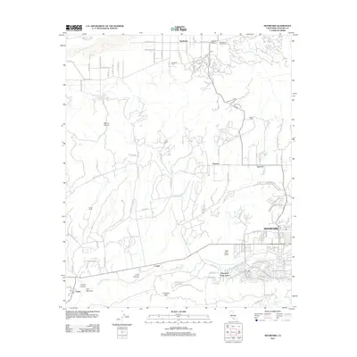
 2022 Moorpark2022 Print · USGSVentura County's fertile valleys and oil-rich ridges come into focus in this contemporary survey of the Moorpark and Bardsdale corridor. Genealogists and researchers can trace local landmarks like Bardsdale Cem, the San Marino Oil Company site, and the rural character of Somis.
 - 2022 Map of Simi Valley West, 2022 Print
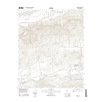
 2022 Simi Valley West2022 Print · USGSVentura County at the start of the 2020s shows the dense suburban expansion of Simi Valley and Moorpark against a backdrop of steep ridgelines. Researchers can trace local heritage at El Rancho Simi Pioneer Cem or explore the rugged network of the Edison Fire Rd.
End of results
Showing maps 1-20 of 20
Top cities near Moorpark
- Los Angeles historical maps
- Thousand Oaks historical maps
- Simi Valley historical maps
- Camarillo historical maps
- Santa Paula historical maps
- Calabasas historical maps
See more
Top neighborhoods of Moorpark
Frequently asked questions
- What are the different types of historical maps available for Moorpark?
- What is the oldest map of Moorpark?
- Where can I purchase historical maps of Moorpark for my home or office?
- Where can I download high-res historical maps of Moorpark?
- Are there historical topographic maps available for Moorpark?
- Is there historical aerial imagery available for Moorpark?
- Where are historical maps of Moorpark sourced from?